


StreetPilot 2720 Owner’s Manual 19
VIEWING THE MAP AND USING THE TOOLS
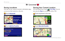
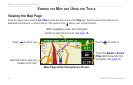
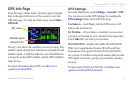
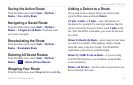
GPS Info Page
From the map or Main menu, touch the signal strength
bars in the upper-left corner of the screen to view the
GPS Info page. Or, from the Main menu, touch Tools >
GPS Info.
Sky view
Satellite signal
strength bars
The sky view shows the satellites you are receiving. The
satellite signal strength bars indicate the strength of each
satellite signal. A solid bar indicates your StreetPilot has
a strong fix on that GPS satellite, and the GPS satellite is
ready for use.
For more information about GPS, see http://www
.garmin.com/aboutGPS/.
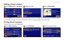
GPS Settings
From the Main menu, touch Settings > General > GPS.
You can also access the GPS Settings by touching the
GPS Settings button on the GPS Info page.
Use Indoors—touch Yes to turn the GPS receiver off
and use the unit indoors.
Set Position—if Use Indoors is enabled, you can select
a location on the map as your current location (position).
Touch OK after you select your location.
WAAS/
EGNOS—disable and enable WAAS/EGNOS.
Wide Area Augmentation System (WAAS) and Euro
Geostationary Navigation Overlay Service (EGNOS)
are systems of satellites and ground stations that provide
GPS signal corrections, giving you even better position
accuracy.
To learn about WAAS and EGNOS, visit
http://www
.garmin.com/aboutGPS/waas.html.