


GPS 400 Quick Reference
190-00140-61 Rev. E
10
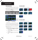
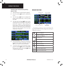
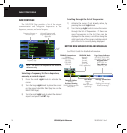
Viewing airport information by facility
name or city:
1) Select the Airport Location Page (see page 6).
2) Press the small right knob to activate the
cursor.
3) Turn the large right knob to highlight the
facility name (second line) or the city (third
line) field.
4) Turn the small and large right knob to enter
the facility name or city location of the desired
destination waypoint. When spelling the
facility name or city, the GPS 400’s Spell’N’Find
feature will select the first entry in the database
based upon the characters that have been
entered up to that point.
5) Once the identifier is entered, the information
for that airport appears on the page. Press the
ENT Key to accept the selected identifier.
6) To view the other airport information pages,
press the small right knob to remove the
flashing cursor and turn the small right knob
to select the desired page.
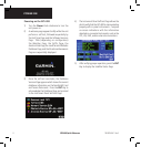
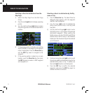
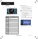
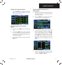
DEFAULT NAV PAGE
Course Deviation
Indicator (CDI)
User-selectable
Data Fields
Active Leg of Flight Plan
TO/FROM Flag
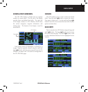
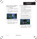
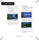
The following symbols are used on the Default NAV
Page (directly below the CDI), to depict the ‘active leg’ of
a flight plan or direct to:
Direct-to a Waypoint
Course to a Waypoint, or Desired Course
between Two Waypoints
Procedure Turn
Procedure Turn
Vectors-to-Final
DME Arc to the Left
DME Arc to the Right
Left-hand Holding Pattern
Right-hand Holding Pattern
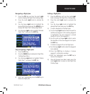
DEFAULT NAV PAGE