


11
First Time Fix
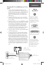
The first time you power up your new GPS 17, the
receiver must be given an opportunity to collect satellite data
and establish its present position. To ensure proper initializa-
tion, the GPS 17 is shipped from the factory in AutoLocate
mode, which will allow the receiver to “find itself” anywhere
in the world.
Once the GPS17 is installed and powered on, it will
begin to search for satellites.The GPS 17 will output naviga
-
tion data once it has calculated an initial position fix. By
default, the following data will be output in NMEA 0183,
Version 2.0 format:
• Latitude/Longitude/Altitude (GPGGA, GPRMC)
• Velocity (GPRMC)
• Date/Time (GPRMC)
• Error Estimates (PGRME)
• Satellite and Receiver Status (GPGSA, GPGSV,
PGRMB, PGRMT)
WAAS Capability
The GPS 17 is capable of receiving WAAS (Wide Area
Augmentation System) satellite signals. WAAS is an FAA
(Federal Aviation Administration) funded project to improve
the overall accuracy and integrity of the GPS signal for avia-
tion use, but land/sea based users may also benefit from this
system. At this time, the system is still in the development
stage and is not fully operational.
There are currently two WAAS satellites that can be
received in the U.S.A., one over the Atlantic Ocean and
one over the Pacific Ocean, in a geo-stationary orbit over the
equator. Effective use of the WAAS satellite signal may be
limited by your geographic location in relation to those satel
-
lites, now in developmental service. WAAS satellite signal
reception requires an absolute clear view of the sky and
works best when there are no nearby obstructions such as
buildings, mountains, etc. WAAS satellites will be numbered
33 or higher on the sky view on your NMEA device.
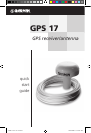
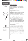
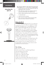
Operation
Using the
GPS 17
GPS 17 QSG rev C.indd 11 10/27/2004 11:07:00 AM