


24 GPSMAP 76 Owner’s Manual
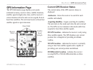
MAIN PAGES > GPS INFORMATION PAGE
3D Differential Location—indicates the receiver is
using DGPS or WAAS differential data on at least four
satellites.
Lost Satellite Reception—indicates that the GPS
receiver has lost satellite reception.
Simulating GPS—indicates the GPSMAP 76 is
running in Simulator Mode and the GPS receiver is
turned off. It is important to remember when using
the Simulator, the GPSMAP 76 cannot be used for
actual navigation.
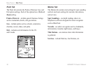
GPS Information Page Options Menu
Press the MENU key to activate the Options Menu
from the GPS Information page. To select an option,
highlight the desired item and then press ENTER.
Start/Stop Simulator— Starts or Stops the Simulator.
Track Up/
North Up—determines if the satellites are
displayed with the rings oriented with North toward the
top of the display or your current track toward the top
of the display.
New Elevation—is used to enter a different elevation.
If the GPS has a 2D GPS Location, entering a known
elevation can increase the GPS accuracy.
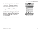
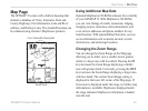
New Location—is used if you have moved the unit
over 600 miles and are having trouble locking onto
satellite signals select New Location.
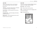
When you select New Location, a second options menu
is displayed. If you select Automatic, the unit switches
to AutoLocate and begins searching for satellites.
This method can take up to five minutes for the unit to
begin navigation.
If Use Map is selected, use the Pointer on the Map
page to indicate your approximate location and the
unit continues to acquire satellites normally using
the almanac for satellite reference. This method does
not require the unit to reinitalize and should receive
satellite signals quickly.
If the unit is in the Simulator mode, the Use Map
feature allows you to choose the location from which
to simulate.