


GPSMAP 5000 Series Owner’s Manual 19
Using Charts
USinG
ChartS
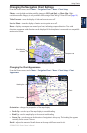
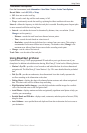
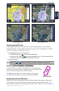
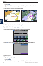
Photo Map at 50%
Photo Map at 100%
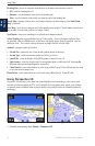
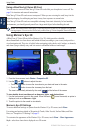
Photo Overlay Off Land Only Photo Overlay
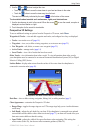
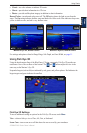
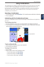
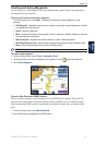
Viewing Aerial Photos
Preprogrammed BlueChart g2 Vision SD cards contain aerial photographs of many landmarks,
marinas, and harbors. Use these photos to help orient yourself to your surroundings or to acquaint
yourself with a marina or harbor prior to arrival.
1. On the Navigation chart, touch a camera icon.
A standard camera icon ( ) indicates an overhead photo.
A camera icon with a cone ( ) indicates a perspective photo. The photo was taken from
the location of the camera, pointed in the direction of the cone.
2. Select Aerial Photo.
NOTE: Touch and to zoom in and out while viewing the aerial photo on the full screen.
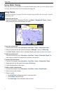
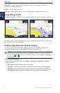
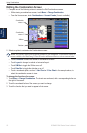
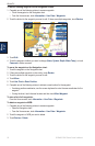
Viewing Current Station InformationCurrent Station Information
If current stations are available in your BlueChart g2 Vision region, they
appear on the Navigation chart as a highlighted arrow. These detailed icons
show the direction and speed of the current at a glance.
Touch Review or the name of the station to display a current graph.
See page 30 for instructions on viewing current station information.
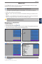
Detailed Road and POI Data
BlueChart g2 Vision contains detailed road and POI data, which includes highly detailed coastal
roads and points of interest (POIs) such as restaurants, lodging, local attractions, and more. For
instructions on searching for and navigating to these POIs, see the “Where To?” section on page 23.
•
•
Current Station iconCurrent Station icon