


nüvi 2200/2300/2400 Series Owner’s Manual 31
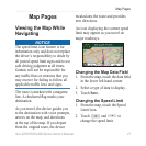
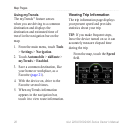
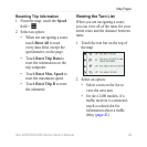
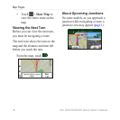
Map Pages
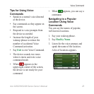
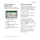
Using the Pedestrian
Navigation Map
In Pedestrian mode, your route is
displayed on a two-dimensional map.
➋➊ ➊
➌
➍
• Touch
➊
to switch between
sections of the route.
• Touch
➋
to view the route
itinerary.
• Touch
➌
to center the map on
your current location.
• Touch
➍
to zoom in and zoom
out.
Public Transit Options
If you have cityXplorer maps
installed, the device calculates a route
that uses a combination of public
transit options, such as riding a bus or
subway, and walking.
cityXplorer maps are not included
with the device. See
http://my.garmin.com to purchase
cityXplorer maps.
The yellow icons indicate the
navigation method used in each
section of the route. For example,
when you see , board a bus at that
point in the route.
The black dots on the map are public
transit stops along your route.
NOTE: You can limit the distance
spent walking during a pedestrian
route (page 51).