


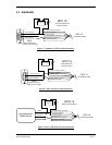


Page 12 GPS 15 TECHNICAL SPECIFICATIONS
Rev. A P/N 190-00266-00
3.2.5 GPS Satellites in View (GSV)
$GPGSV,<1>,<2>,<3>,<4>,<5>,<6>,<7>,...<4>,<5>,<6>,<7>*hh<CR><LF>
<1> Total number of GSV sentences to be transmitted
<2> Number of current GSV sentence
<3> Total number of satellites in view, 00 to 12 (leading zeros will be transmitted)
<4> Satellite PRN number, 01 to 32 (leading zeros will be transmitted)
<5> Satellite elevation, 00 to 90 degrees (leading zeros will be transmitted)
<6> Satellite azimuth, 000 to 359 degrees, true (leading zeros will be transmitted)
<7> Signal to noise ratio (C/No) 00 to 99 dB, null when not tracking (leading zeros will be transmitted)
NOTE: Items <4>,<5>,<6> and <7> repeat for each satellite in view to a maximum of four (4) satellites
per sentence. Additional satellites in view information must be sent in subsequent bursts of NMEA 0183
data. These fields will be null if unused.
3.2.6 Recommended Minimum Specific GPS/TRANSIT Data (RMC)
$GPRMC,<1>,<2>,<3>,<4>,<5>,<6>,<7>,<8>,<9>,<10>,<11>,<12>*hh<CR><LF>
<1> UTC time of position fix, hhmmss format
<2> Status, A = Valid position, V = NAV receiver warning
<3> Latitude, ddmm.mmmm format (leading zeros will be transmitted)
<4> Latitude hemisphere, N or S
<5> Longitude, dddmm.mmmm format (leading zeros will be transmitted)
<6> Longitude hemisphere, E or W
<7> Speed over ground, 000.0 to 999.9 knots (leading zeros will be transmitted)
<8> Course over ground, 000.0 to 359.9 degrees, true (leading zeros will be transmitted)
<9> UTC date of position fix, ddmmyy format
<10> Magnetic variation, 000.0 to 180.0 degrees (leading zeros will be transmitted)
<11> Magnetic variation direction, E or W (westerly variation adds to true course)
<12> Mode indicator, A = Autonomous, D = Differential, E = Estimated, N = Data not valid
3.2.7 Estimated Error Information (PGRME)
$PGRME,<1>,M,<2>,M,<3>,M*hh<CR><LF>
<1> Estimated horizontal position error (HPE), 0.0 to 999.9 meters
<2> Estimated vertical position error (VPE), 0.0 to 999.9 meters
<3> Estimated position error (EPE), 0.0 to 999.9 meters
3.2.8 Map Datum (PGRMM)
The GARMIN Proprietary sentence $PGRMM gives the name of the map datum currently in use by the
GPS sensor. This information is used by the GARMIN MapSource real-time plotting application.
$PGRMM,<1>*hh<CR><LF>
<1> Name of map datum currently in use (variable length field, e.g., “WGS 84”)