


GPS 15 TECHNICAL SPECIFICATIONS Page 11
P/N 190-00266-00 Rev. A
3.2.2 Transmitted Time
The GPS sensor outputs UTC (Coordinated Universal Time) date and time of day in the transmitted
sentences. Prior to the initial position fix, the on-board clock provides the date and time of day. After the
initial position fix, the date and time of day are calculated using GPS satellite information.
The GPS sensor uses information obtained from the GPS satellites to add or delete UTC leap seconds and
correct the transmitted date and time of day. The transmitted date and time of day for leap second
correction follow the guidelines in “National Institute of Standards and Technology Special Publication
432 (Revised 1990)” (for sale by the Superintendent of Documents, U.S. Government Printing Office,
Washington, D.C., 20402, U.S.A.).
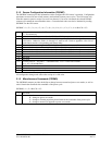
When a positive leap second is required, the second is inserted beginning at 23h 59m 60s of the last day of
a month and ending at 0h 0m 0s of the first day of the following month. The minute containing the leap
second is 61 seconds long. The GPS sensor would have transmitted this information for the leap second
added December 31, 1989 as follows:
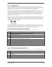
Date Time
311289 235959
311289 235960
010190 000000
If a negative leap second should be required, one second will be deleted at the end of some UTC month.
The minute containing the leap second will be only 59 seconds long. In this case, the GPS sensor will not
transmit the time of day 23h 59m 59s for the day from which the leap second is removed.
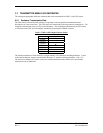
3.2.3 Global Positioning System Fix Data (GGA)
$GPGGA,<1>,<2>,<3>,<4>,<5>,<6>,<7>,<8>,<9>,M,<10>,M,<11>,<12>*hh<CR><LF>
<1> UTC time of position fix, hhmmss format
<2> Latitude, ddmm.mmmm format (leading zeros will be transmitted)
<3> Latitude hemisphere, N or S
<4> Longitude, dddmm.mmmm format (leading zeros will be transmitted)
<5> Longitude hemisphere, E or W
<6> GPS quality indication, 0 = fix not available, 1 = Non-differential GPS fix available, 2 =
Differential GPS (DGPS) fix available, 6 = Estimated
<7> Number of satellites in use, 00 to 12 (leading zeros will be transmitted)
<8> Horizontal dilution of precision, 0.5 to 99.9
<9> Antenna height above/below mean sea level, -9999.9 to 99999.9 meters
<10> Geoidal height, -999.9 to 9999.9 meters
<11> Not used.
<12> Not used.
3.2.4 GPS DOP and Active Satellites (GSA)
$GPGSA,<1>,<2>,<3>,<3>,<3>,<3>,<3>,<3>,<3>,<3>,<3>,<3>,<3>,<3>,<4>,<5>,<6>*hh<CR><LF>
<1> Mode, M = manual, A = automatic
<2> Fix type, 1 = not available, 2 = 2D, 3 = 3D
<3> PRN number, 01 to 32, of satellite used in solution, up to 12 transmitted (leading zeros will be
transmitted)
<4> Position dilution of precision, 0.5 to 99.9
<5> Horizontal dilution of precision, 0.5 to 99.9
<6> Vertical dilution of precision, 0.5 to 99.9