


SP - 3 E3494S01F
Effective radar display area: 216 x 216 dots
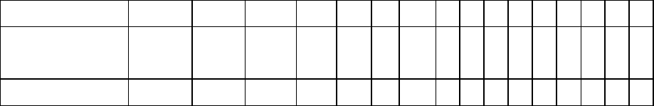
4.2. Range, Range Ring Interval (RRI), Number of Rings
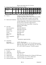
Range (NM) 0.125 0.25 0.5 0.75 1 1.5 2 3 4 6 8 12 16 24 36 48
RRI (NM) 0.0625 0.125 0.125 0.25 0.2
5
0.5 0.5 1 1 2 2 3 4 6 12 12
Number of Rings 2 2 4 3 4 3 4 3 4 3 4 4 4 4 3 4
Maximum range: M1722/C: 24nm, M1732/1742(C): 36nm, M1762/C: 48nm
4.3. Markers Heading Line, Bearing Scale, Range Rings,
Variable Range Marker (VRM), Electronic Bearing Line (EBL),
Alarm Zone, Waypoint Mark (navigation input required)
4.4. Alphanumeric Indications Range, Range Ring Interval, Interference Rejection (IR),
Variable Range Marker (VRM), Electronic Bearing Line (EBL),
Stand-by (ST-BY), Guard Alarm (G(IN), G(OUT)),
Echo Stretch (ES), Echo Tailing (TRAIL), Trailing Time,
Watchman (WATCHMAN),
4.5. Input Data IEC 61162-1
Own ship’s position: GGA>RMC>RMA>GLL
Ship’s speed: RMC>RMA>VTG>VHW
Bearing (True): HDT>HDG
*1
>HDM
*1
Course: RMC>RMA>VTG
Water depth: DPT>DBT
Wind: MWV>VWT>VWR
Water Temperature: MTW
Time: ZDA
*1
: calculated by magnetic deviation
4.6. Output Data
Alarm signal 12 VDC, 100 mA or less
NMEA 0183 Ver1.5 GGA, GLL, RMA, RMC, GTD, VTG, ZDA (GPS data required)
RMB, WPL, BWC or BWR, APB, AAM, BOD, XTE, VHW, MTW,
DPT or DBT, DBS (ETR required), TTM (ARPA required)
5. PLOTTER FUNCTION
5.1. Projection Mercator
5.2. Usable Area 85 latitude or below
5.3. Effective Area 133.4 x 97.3 mm
5.4. Display pixels 240 x 320 dots (M1722 series), 234 x 320 dots (M1722C series)
5.5. Position Indication Latitude/longitude, Loran C LOP or DECCA LOP
5.6. Effective Projection Area 0.125 nm to 1,024 nm (at equatorial area)