2.5
SYSTEM PAGE
2.5
SYSTEM PAGE
Advanced Screen
37
Advanced Screen
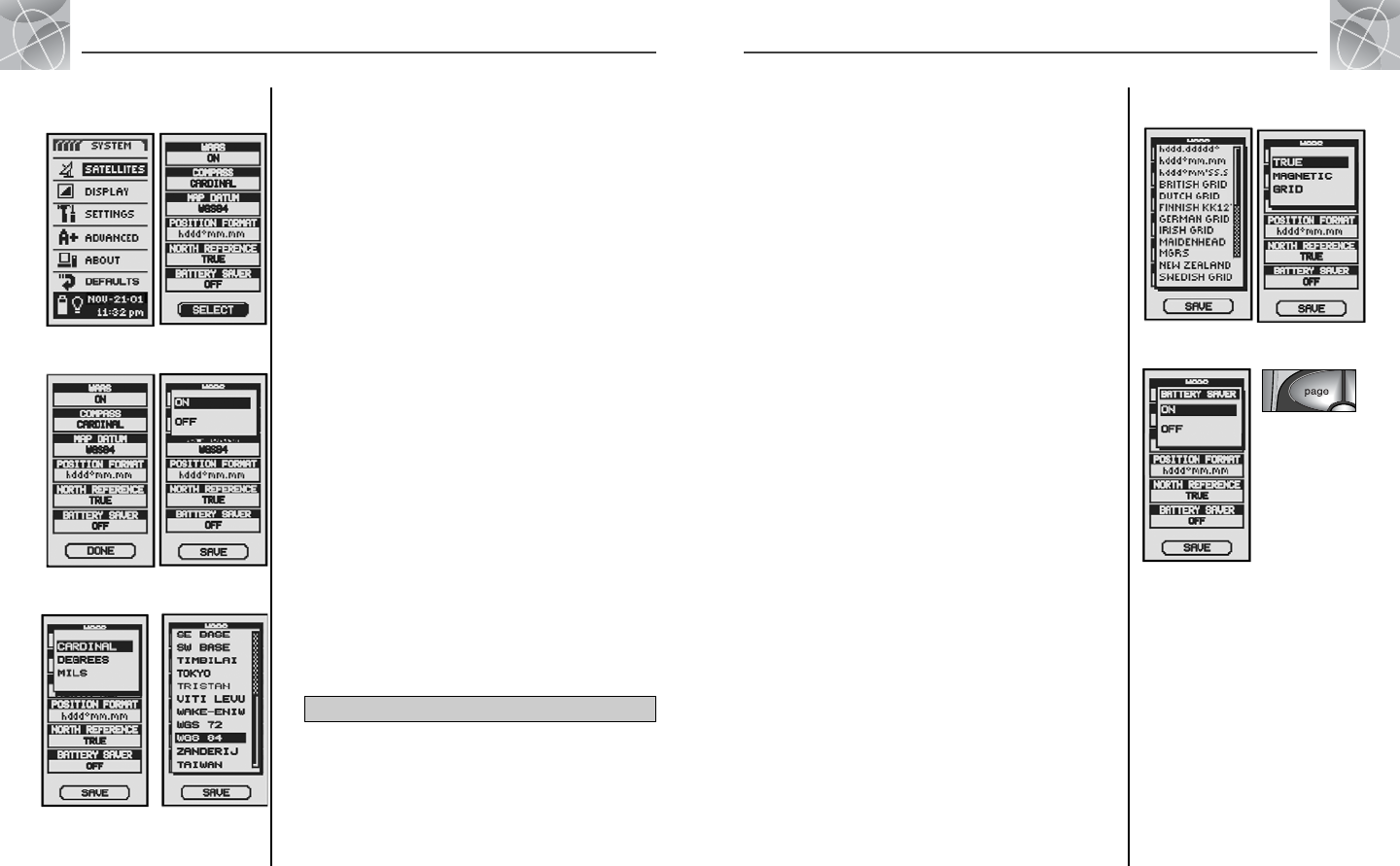
• Position Format
To change the format the device uses to display location coordinates,
highlight POSITION FORMAT Ẇ. Press the ENTER button to bring up the
menu select from the following: hddd.ddddd° (degrees, decimal
degrees), hddd°mm.mm (degrees, minutes, decimal minutes),
hddd°mm’ss.s (degrees, minutes, seconds, decimal seconds), British
Grid, Dutch Grid, Finnish KK127 Grid, German Grid, Irish Grid,
Maidenhead, MGRS (Military Grid Reference System), New Zealand,
Qatar Grid, Swedish Grid, Swiss Grid, Taiwan Grid, User Defined Grid,
User Defined Grid, UTM/UPS (Universal Transfer Mercator/Universal
Polar Stereograph), W Malaysian R Ẋ.
• North Reference
To change the unit’s method of orientation to the earth’s magnetic field,
highlight NORTH REFERENCE Ẇ (see “About North Reference,”
page 42). Press the ENTER button to bring up the menu. Select TRUE for
true north, MAGNETIC for magnetic north or GRID for grid north ẋ.
• Battery Saver
To conserve battery life, highlight BATTERY SAVER Ẇ. Press the ENTER
button to bring up the menu. Select ON or OFF Ẍ.
4. To save changes made, highlight and select SAVE Ẇ. To exit this function
without saving changes, press the PAGE button ẗẖ.
Ẍ Set Interval
ẋ Set
Orientation
Using the Advanced Screen
From the Advanced screen, you can change the advanced operational
parameters used by your GPS 100.
To change advanced parameters:
1. From the System page, highlight using the ZOOM IN/OUT button and
select ADVANCED by pressing the ENTER button Ẅ. A menu of advanced
parameters appears. SELECT will be highlighted ẅ.
2. Press the ENTER button and the title of the first data field will begin to
blink Ẇ. Highlight field you wish to change (highlighted field will blink).
3. Choose from the following. (You only need to select the settings you
want to change.)
• WAAS
To turn the unit’s WAAS receiver on or off, highlight WAAS Ẇ. (See
“What is WAAS,” page 42.) Press the ENTER button to bring up the
menu. Select ON or OFF ẇ.
• Compass
To change the method of indicating direction used by the compass,
highlight COMPASS Ẇ. Press the ENTER button to bring up the menu.
Select CARDINAL (standard N-S-E-W), DEGREES (
<
0°-360°) or
MILS (0000-6400) Ẉ.
• Map Datum
To change the datum used by your unit when comparing information
with a paper map or other navigational reference, highlight MAP DATUM
Ẇ, (see “What is a Map Datum?,” page 42, for details). Press the
ENTER button to bring up the menu. Select the map datum that
matches the item you are comparing ẉ.
NOTE: Most widely used datum is WGS 84
continued
Ẅ Change
Parameters
ẅ Select Data
Fields
ẇ WAAS On/OffẆ First Data
Field Blinks
38
ẉ Map Datum
Settings
Ẉ Set Compass
Ẋ Location
Coordinates
ẗẖ Return to
System Page
Go to Table of Contents


