


8
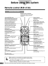
Preface
Navigation systems
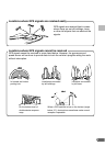
This navigation system uses three different sensing devices to determine the present location
and to track the progress of the vehicle. These three sensors are: a GPS (Global Positioning
System) sensor which uses satellites to determine the current position of the vehicle, a gyro-
scope which determines which direction the vehicle turns, and speedometer pulses which
determine how far the vehicle has traveled. Because this system incorporates a gyroscope
and a speed sensor, the system will be able to display the vehicle's position and track the
vehicle's progress even in areas where the GPS signal may be blocked.
All map data is contained on a removable DVD-ROM. This system integrates this unique map
database with the sensors to automatically plot out a route when a destination is entered.
While driving, the navigation system guides you along the route with pictorial displays and
verbal prompts.
GPS (Global Positioning System)
This system receives signals from 3 or more
GPS satellites (operated by the United States
Department of Defence). They orbit at an
altitude of 13,100 miles (21,000 kilometers) and
determine the vehicle’s position through princi-
ples of triangulation.
There may be a delay before the
actual vehicle's position is dis-
played
Determination of the present vehicle's
position starts when the ignition key is
turned to the ACC or ON positions and
ends when the key is turned OFF. When
the key is first turned to the ACC or ON
positions, there is a slight delay of ap-
proximately one to two minutes before the
present vehicle's position can be dis-
played.
Error from the actual position of the
vehicle
When GPS signals can be received from four or
more satellites, three dimensional positioning
(the latitude, longitude, and altitude) of the
vehicle can be determined. In this case, the
error from the actual position of the vehicle is in
the range of 100 to 655 feet (30 to 200 meters).
When GPS signals can only be received from
three satellites, only two dimensional position-
ing (latitude and longitude) can be determined,
resulting in a slightly increased error. When
GPS signals can only be received from less
than three satellites, positioning of the vehicle
through GPS is not possible. In addition to the
inherent errors from GPS, the error rate can
also be increased if the United States Depart-
ment of Defense deliberately changes the
accuracy rate.
Gyroscope
The gyroscope is a sensor that accurately
measures the angle by which the direction of
a vehicle or other moving body changes.
Gyroscopes are used in inertial navigation
systems for airliners and ships. In this navi-
gation system, the gyroscope is used to-
gether with the speed sensor, making it
possible to display the present position of the
vehicle even in locations where GPS signals
may be blocked.