


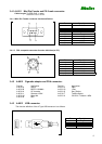
Rikaline
8
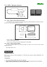
3. After the installation is complete, go to <Device Manager> and select <Ports (COM & LPT)> to verify if a
virtual COM port <USB to Serial Port> was created.
4.3 Important
Verify the COM port # to start using your own navigating software.
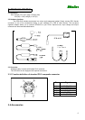
1. Click <Start> menu, select <Settings>, then enter <Control Panel>.
2. After entering <Control Panel>, select <System>.
3. Select <Device Manager>.
4. Find the <Connect Port> and check the Virtual COM Port, which was created by the USB driver. Please
note that the Virtual COM Port number might be different from every computer. Before using navigating
software, please confirm the COM Port numbers created by your computer and provided by your navigation
software. They must be the same Com Port numbers. Otherwise, the navigating software won’t receive the
satellite signal for the un-match COM Port setting.
5. Software Interface
The GPS-6010 interface protocol is based on the National Marine Electronics Association's NMEA 0183
ASC Ⅱ interface specification, which is defined in NMEA 0183, Version 2.2 and the Radio Technical
Commission for Maritime Services (RTCM Recommended Standards For Differential Navstar GPS Service,
Version 2.1, RTCM Special Committee No.104).
5.1 NMEA Transmitted Messages
The GPS-6010 supported by SiRF Technology Inc. also outputs data in NMEA-0183 format as defined by
the National Marine Electronics Association (NMEA), Standard.
The default communication parameters for NMEA output are 4800 baud, 8 data bits, stop bit, and no parity.
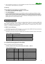
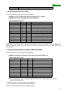
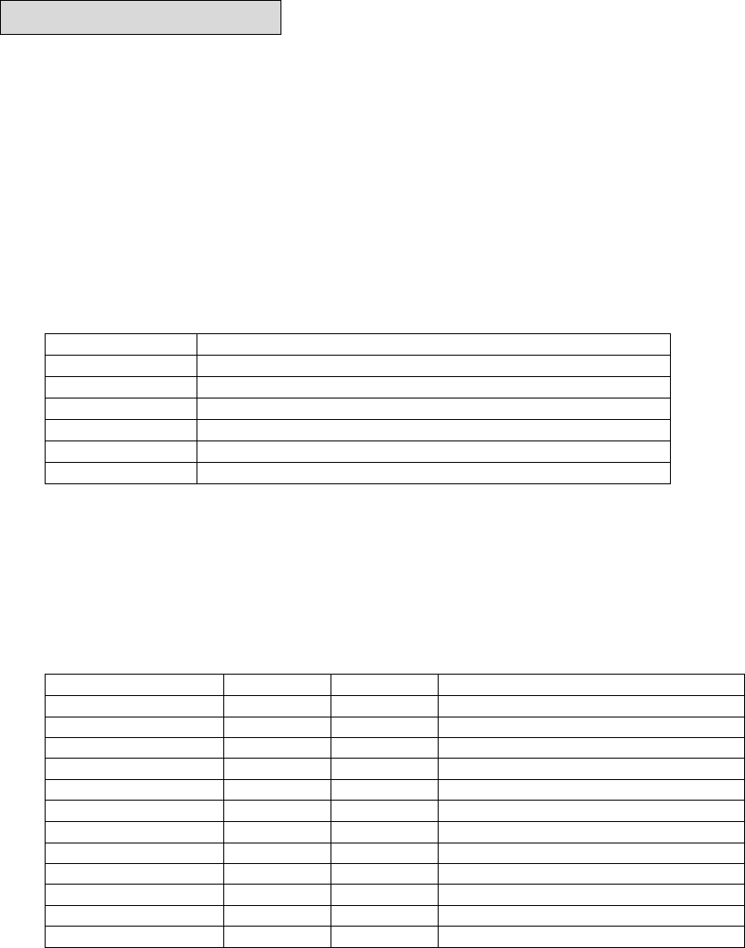
Table 5-1 NMEA-0183 Output Messages
NMEA Sentence Description
GPGGA Global positioning system fixed data
GPGLL Geographic position latitude \ longitude
GPGSA GNSS DOP and active satellites
GPGSV GNSS satellites in view.
GPRMC Recommended minimum specific GNSS data
GPVTG Coruse over ground and ground speed
5.1.1 Global Positioning System Fix Data (GGA)
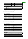
Table 5-2 contains the values for the following example:
$GPGGA,161229.487,3723.2475,N,12158.3416,W,1,07,1.0,9.0,M, , , ,0000*18
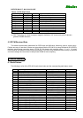
Table 5-2 GGA Data Format
Name Example Units Description
Message ID $GPGGA GGA protocol header
UTC Time 161229.487 Hhmmss.sss
Latitude 3723.2475 ddmm.mmmm
N/S Indicator N N=north or S=south
Longitude 12158.3416 dddmm.mmmm
E/W Indicator W E=east or W=west
Position Fix Indicator 1 See Table 5-3
Satellites Used 07 Range 0 to 12
HDOP 1.0 Horizontal Dilution of Precision
MSL Altitude 9.0 Meters
Units M Meters
Geoid Separation Meters