


46 Magellan Meridian GPS Receiver
Refe ren ce
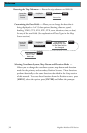
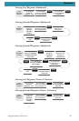
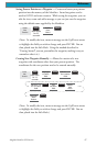
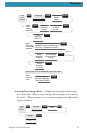
Selecting Uploaded Waypoints (Nearest To Position)
From
Database
Screen
Use up/down
arrows to highlight
uploaded detailed
map name
Use left/right
arrows to set
Find By to
Nearest To
ENTER
ENTER
Use up/down
arrows to hightlight
waypoint
Use up/down
arrows to
highlight
category
ENTER
Use up/down
arrows to highlight
subcategory
ENTER
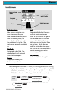
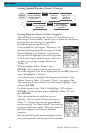
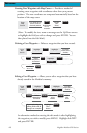
Selecting Waypoints (Nearest To Other Categories)
This will allow you to change the “Nearest To” from Position to any
other category in the database. The first step is to follow the instructions
provided above for selecting user, preloaded or
uploaded waypoints using Nearest To.
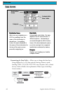
In the example here, the category “Waterways” was
selected from the preloaded list of categories. Notice
that the highlight is on “Position”. As you know,
you can move the highlight to one of the waypoints
in the list by using the up/down arrows. But in this
example, we are going to change “Position” to
“Dallas, Tx”.
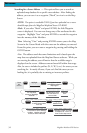
With the highlight still on “Position” press
[ENTER]. (If you already used the arrow keys and
one of the waypoints in the list are highlighted, use the [ESC] button to
return the highlight to “Position”.)
A drop-down menu is displayed with the options of Position, Cities,
Address, Cursor or Other. (The option “Cursor” only appears if the
Map screen is in th Cursor Mode.) For this example, highlight “Cities”
and press [ENTER].
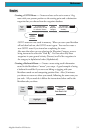
Use the keyboard to enter “DALL” and highlight “OK” and press
[ENTER]. Use the up/down arrows to highlight “Dallas, TX” and
press [ENTER].
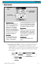
This is the screen that you would see on your
Meridian. Here we see the 20 closest waterways to
Dallas, TX. If your screen does not appear like the
one here and says “No Objects Found”, then redo this
procedure and be sure to select “Waterways” from the
preloaded categories, not from your uploaded
categories.
Note that the bearing and distance displayed is from
your present position or the last position fix obtained.