


ii Magellan Meridian GPS Receiver
Reference
Power/Backlight/Contrast ..................................................................... 20
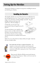
Turn the Meridian On ................................................................................. 20
Turn the Meridian Off................................................................................. 20
Alternate Turn On/Off ................................................................................ 20
Using the Display Backlight......................................................................... 21
Adjusting the Display Contrast .................................................................... 21
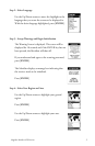
Selecting NAV Screens ................................................................................. 22
Returning to Last Viewed NAV Screen ........................................................ 22
Map Screen ........................................................................................... 22
Setting the Map Detail................................................................................. 25
Customizing the Map Display ..................................................................... 25
Selecting Map Items .............................................................................. 25
Turning On/Off Display Waypoints ...................................................... 25
Turning On/Off Track Lines .................................................................. 25
Turning On/Off Topographic Lines ....................................................... 26
Turning On/Off Displayed POI’s .......................................................... 26
Globally Turning Map Items On/Off..................................................... 26
Setting Up Map Data Fields......................................................................... 27
Setting up Map Data Fields ................................................................... 27
Turning Map Info On/Off ................................................................. 27
Selecting the Map Information .......................................................... 27
Two Data Fields Description.............................................................. 27
Changing the Data Fields .............................................................. 29
Street Information Description .......................................................... 29
Horizontal Profile Description ........................................................... 29
Terrain Projection Description ........................................................... 31
Changing the Map Orientation ................................................................... 32
Selecting Primary Usage ............................................................................... 32
Selecting Track Mode ................................................................................... 32
Auto vs. Auto Detailed........................................................................... 33
Compass Screen .................................................................................... 34
Customizing the Data Fields ........................................................................ 35
Large Data Screen ................................................................................. 35
Customizing the Data Fields ........................................................................ 36