


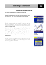
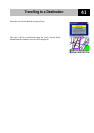

Travelling to a Destination
36
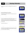
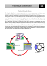
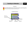
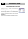
Guidance Screen
The Guidance screen is the most commonly used screen in the Magellan RoadMate and provides you
with detailed information about where you are and where you are going.
* WAAS and EGNOS are two satellite networks, similar to the GPS satellite network, that provide
increased accuracy for the Magellan RoadMate.
As you travel, the Guidance screen constantly updates your location and provides you with not only a
map, but also a visual indication of where you are on the map.
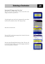
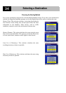
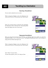
Changing the Map Zoom Levels
You can zoom in by pressing the "+" button or zoom out by pressing the "-" button.
Planned Route (pink)
Estimated Time
to Destination
Position Cursor
(shows your location and
the direction in which you
are heading)
Distance to
Destination
Direction of
Destination
Direction of
Travel and GPS
Signal Strength
Next Manoeuvre
Command
Blue = WAAS/EGNOS* Signal
Green = Strong Signal
Y
ellow = Average Signal
Red = No Signal
Distance to Next
Manoeuvre
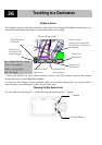
’+’ Button
Zoom In Button