


82
NOTE:
In North Up and Course Up, the present position arrow appears in
the center of the map page. In Track Up, the position arrow appears
centered in the lower third of the page.
Navionics
Charts
Your unit can display Navionics
electronic charts on MMCs. They
work just like a MapCreate custom map on an MMC.
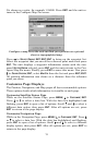
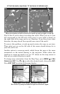
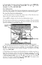
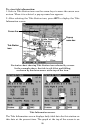
Left, entrance to Chesapeake Bay in a MapCreate 6 custom map, 10
mile zoom. Center, same position on Navionics chart at 11.15 mile zoom
and right, 5.56 mile zoom.
To display a Navionics chart:
1. Install the Navionics MMC in the memory card compartment and
turn on the unit. (For full card install instructions, see Sec. 2.)
WARNING:
You should never format the MMC containing your
Navionics chart. Formatting the MMC will permanently
erase the chart from the card.
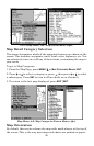
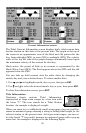
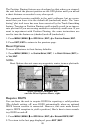
2. From the Map Page, press
MENU|↓ to MAP DATA|ENT|↓ to NAVIONICS
MAP CHOICE|ENT. Use ↑ or ↓ to select the Map Name, then press
ENT|EXIT|EXIT.
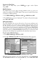
These figures show menu sequence (from left to right) for selecting a
Navionics chart for the South Chesapeake Bay area.