


27
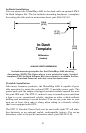
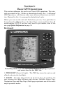
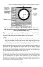
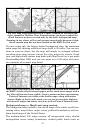
This screen shows a graphical view of the satellites that are in view. Each
satellite is shown on the circular chart relative to your position. The point in
the center of the chart is directly overhead. The small inner ring represents
45° above the horizon and the large ring represents the horizon. North is at
the top of the screen. You can use this to see which satellites are obstructed
by obstacles in your immediate area if the unit is facing north.
The GPS receiver is tracking satellites that are in bold type. The re-
ceiver hasn't locked onto a satellite if the number is grayed out, there-
fore it isn't being used to solve the position.
Beneath the circular graph are the bar graphs, one for each satellite in
view. Since the unit has twelve channels, it can dedicate one channel
per visible satellite. The taller the bar on the graph, the better the unit
is receiving the signals from the satellite.
NOTE:
One of the data display options for the Satellite Status page is "Po-
sition Error" (horizontal position error), which can appear in one of
the page's data boxes. If you turn on Position Error, it will show you
the expected error from a benchmark location. In other words, if the
Position Error box shows 50 feet, then the position shown by the
unit is estimated to be within 50 feet of the actual location.
This also gives you an indicator of the fix quality the unit currently
has. The smaller the position error number, the better (and more ac-
curate) the fix is. If the position error flashes dashes, then the unit
hasn't locked onto the satellites, and the number shown isn't valid.
(For details, see the Customize Page Displays entry in Sec. 5.)
The Satellite Status Page has its own menu, which is used for setting
various options. (Options and setup are discussed in Sec. 5). To access
the Satellite Status Page Menu, from the Status Page, press
MENU.
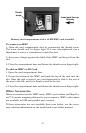
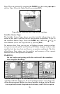
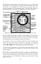
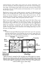
Navigation Page
This screen has a compass rose that not only shows your direction of
travel, but also the direction to a recalled waypoint. To get to the Navi-
gation Page: Press
PAGES|→ or ← to NAVIGATION|EXIT.
The navigation screen looks like the one below when you're not navi-
gating to a waypoint or following a route or trail. Your position is
shown by an arrow in the center of the screen. Your trail history, or
path you've just taken, is depicted by the line extending from the arrow.
The arrow pointing down at the top of the compass rose indicates the cur-
rent track (direction of travel) you are taking.