


6
Like most GPS receivers, this unit doesn’t have a compass or any other
navigation aid built inside. It relies solely on the signals from the sat-
ellites to calculate a position. Speed, direction of travel, and distance
are all calculated from position information. Therefore, in order for the
GlobalMap to determine direction of travel, you must be moving and
the faster, the better. This is not to say that it won’t work at walking or
trolling speeds — it will. There will simply be more "wandering" of the
data shown on the display.
GPS is plenty accurate for route navigation, but the U.S. Federal Avia-
tion Administration has special needs for aircraft traffic control that go
beyond basic GPS. The FAA has a plan under way to boost GPS per-
formance even further with its Wide Area Augmentation System, or
WAAS. This GPS add-on will include a time control element that will
help airliners fly closer together while avoiding collisions. In addition to
carefully spacing airplanes along travel corridors, WAAS will eventu-
ally make instrument landings and takeoffs more accurate as it re-
places existing aviation navigation systems.
Non-aviators can use WAAS signals to make their GPS navigation even
more accurate. Your unit receives both GPS and WAAS signals. How-
ever, WAAS has some limits you should know about.
First, the U.S. government has not completed construction of the WAAS
system, so it is not yet fully operational. The ground stations are in
place, but only a few of the needed WAAS satellites have been launched.
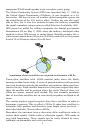
WAAS can boost the accuracy of land GPS navigation, but the system is
designed for aircraft. The satellites are in a fixed orbit around the
Equator, so they appear very low in the sky to someone on the ground
in North America. Aircraft and vessels on open water can get consis-
tently good WAAS reception, but terrain, foliage or even large man-made
structures frequently block the WAAS signal from ground receivers.
You'll find that using your GPS receiver is both easy and amazingly
accurate. It’s easily the most accurate method of electronic navigation
available to the general public today. Remember, however, that this
receiver is only a tool. Always have another method of navigation avail-
able, such as a map or chart and a compass.
Also remember that this unit will always show navigation information
in the shortest line from your present position to a waypoint, regardless
of terrain! It only calculates position, it can’t know what’s between you
and your destination, for example. It’s up to you to safely navigate
around obstacles, no matter how you’re using this product.