


HOLUX
4
Cold start 45 sec., averaged
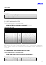
4) Position accuracy:
A) Non DGPS (Differential GPS)
Position 5-25 meter CEP without SA
Velocity 0.1 meters/second, without SA
Time 1 microsecond synchronized GPS time
B) DGPS (Differential GPS)
Position 1 to 5 meter, typical
Velocity 0.05 meters/second, typical
C)EGNOS/WAAS/Beacon
Position < 2.2 meters, horizontal 95% of time
< 5 meters, vertical 95% of time
5) Dynamic Conditions:
Altitude 18,000 meters (60,000 feet) max
Velocity 515 meters / second (1000 knots) max
Acceleration 4 G, max
Jerk 20 meters/second, max
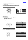
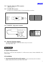
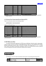
1.3.5 Interfaces
1) Dual channel RS-232 or TTL compatible level, with user selectable baud rate (4800-Default, 9600, 19200,
38400).
2) NMEA 0183 Version 2.2 ASCII output (GPGGA, GPGSA, GPGSV, GPRMC, option GPGLL, GPVTG).
3) Real-time Differential Correction input (RTCM SC-104 message types 1,2 and 9).
4) SiRF binary protocol.
2. Operational characteristics
2.1 Initialization
As soon as the initial self-test is complete, the GM-210 begins the process of satellite acquisition and
tracking automatically. Under normal circumstances, it takes approximately 45 seconds to achieve a position fix,
38 seconds if ephemeris data is known. After a position fix has been calculated, information about valid position,
velocity and time is transmitted over the output channel.
The GM-210 utilizes initial data, such as last stored position, date, time and satellite orbital data, to achieve
maximum acquisition performance. If significant inaccuracy exists in the initial data, or the orbital data is
obsolete, it may take more time to achieve a navigation solution. The GM-210 Auto-locate feature is capable of
automatically determining a navigation solution without intervention from the host system. However, acquisition
performance can be improved as the host system initializes the GM-210 in the following situation:
1) Moving further than 500 kilometers.
2) Failure of data storage due to the inactive internal memory battery.
2.2 Navigation
After the acquisition process is complete, the GM-210 sends valid navigation information over output
channels. These data include:
1) Latitude/longitude/altitude
2) Velocity
3) Date/time
4) Error estimates
5) Satellite and receiver status
The GM-210 sets the default of auto-searching for real-time differential corrections in RTCM SC-104
standard format, with the message types 1, 5, or 9. It accomplishes the satellite data to generate a differential
(DGPS) solution. The host system, at its option, may also command the GM-210 to output a position whenever
a differential solution is available.