


HOLUX
11
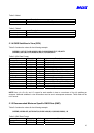
Status A A=data valid or V=data not valid
Latitude 3723.2475 ddmm.mmmm
N/S Indicator N N=north or S=south
Longitude 12158.3416 dddmm.mmmm
E/W Indicator W E=east or W=west
Speed Over Ground 0.13 knots
Course Over Ground 309.62 degrees True
Date 120598 ddmmyy
Magnetic Variation(1) degrees E=east or W=west
Checksum *10
<CR> <LF> End of message termination
1. SiRF Technology Inc. does not support magnetic declination. All “course over ground” data are geodetic
WGS84 directions.
5.1.6 Course Over Ground and Ground Speed (VTG)
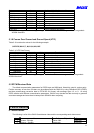
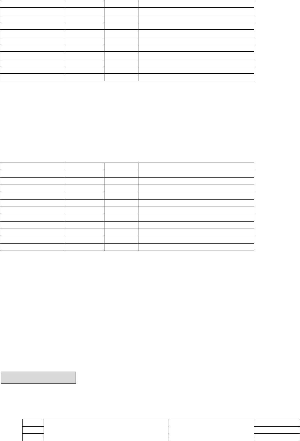
Table 5-10 contains the values for the following example:
$GPVTG,309.62,T, ,M,0.13,N,0.2,K*6E
Table 5-10 VTG Data Format
Name Example Units Description
Message ID $GPVTG VTG protocol header
Course 309.62 degrees Measured heading
Reference T True
Course degrees Measured heading
Reference M Magnetic(1)
Speed 0.13 knots Measured horizontal speed
Units N Knots
Speed 0.2 km/hr Measured horizontal speed
Units K Kilometers per hour
Checksum *6E
<CR> <LF> End of message termination
1. SiRF Technology Inc. does not support magnetic declination. All “course over ground” data are geodetic
WGS84 directions.
5.2 RTCM Received Data
The default communication parameters for DGPS Input are 9600 baud, 8 data bits, stop bit, and no parity.
Position accuracy of less than 5 meters can be achieved with the GM-210 by using Differential GPS (DGPS)
real-time pseudo-range correction data in RTCM SC-104 format, with message types 1,2, or 9. As using
DGPS receiver with different communication parameters, GM-210 may decode the data correctly to generate
accurate messages and save them in battery-back SRAM for later computing.
6. Earth Datums
6.1 Earth Datums
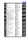
The following is a list of the GM-210 earth datum index and the corresponding earth datum name:
Item Datum Reference Ellipsoid Data name
1 Adindan - Ethiopia Clarke 1880 Data1.dat
2 Afgooye – Somalia Krassovsky Data2.dat