


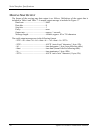

Serial Interface Specifications
Apollo GX50/60/65 Installation Manual
57
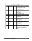
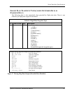
Table 6 Moving Map ASCII Navigation Data
ID Data Format Length Description
A sddmmhh 9 Present latitude
s =sign: N for north, S for south
dd = degrees
mm = minutes
hh = hundredths of minutes
B sdddmmhh 10 Present longitude
s = sign: E for east, W for west
ddd = degrees
mm = minutes
hh = hundredths of minutes
C ddd 3 Track (magnetic): ddd = degrees
D ddd 3 Ground speed: ddd = knots
E ddddd 5 Distance to active waypoint: ddddd = nm x 10
G sdddd 5 Cross track error:
s = sign: R for right, L for left of course
dddd = distance off course, hundredths of nm
I dddd 4 Desired track (magnetic):
dddd = degrees x 10
K ddd[dd] 3 to 5 Active waypoint identifier:
ddd[dd] = ASCII waypoint identifier
L dddd 4 Bearing to active waypoint (magnetic):
dddd = degrees x 10
Q sddd 4 Magnetic variation:
s = sign: E for east, W for west
ddd = degrees x 10
T ---A----- 9 Warnings: The 4th character will be an “A”
when the navigation data is flagged, otherwise,
all characters will be dashed. All other
navigation data will be dashed when it is
flagged.