


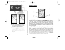
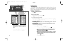
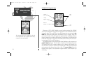
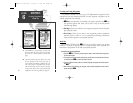

GPSMAP 230 Navigation Page
Whenever a GOTO, MOB, TracBack or route has been activated, the GPSMAP
230 will provide digital and graphic steering guidance to the destination with the
Navigation Page. The top half of the nav page features four user-selectable data
fields that display the bearing (BRG) and distance (DIS) to waypoint, along with
your current course (COG) and speed over ground (SOG). In addition, there’s a
moving compass tape to indicate the direction you’re heading. Two additional data
fields at the bottom of the page show the estimated time enroute (ETE) and veloc-
ity made good (VMG) to your destination.
The middle section of the screen provides visual guidance to the waypoint on a
graphic highway display. The line down the center of the highway represents
your desired track, while a graphic indication of the distance and direction you
are off course is shown on a scale at the bottom right of the page (the selected
scale represents the distance from side to side). The arrow pointer below the
highway always points to the destination waypoint relative to the direction you
are moving.
30
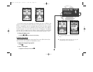
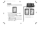
The Navigation Page can be configured to show the
active waypoint, all route waypoints and/or nearby
waypoints on the graphic highway.
SECTION
4
NAVIGATION PAGE
Overview
Data
Fields
CDI
Scale
Graphic
Highway
Graphic
Compass Tape
Pointer to
Waypoint
update on 230.qxd 1/12/00 11:22 AM Page 30