


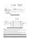
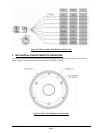

190-00885-07 GPS 17x HVS Technical Specifications Rev. A
Page 15
4.2.7 Recommended Minimum Specific GPS/TRANSIT Data (GPRMC)
$GPRMC,<1>,<2>,<3>,<4>,<5>,<6>,<7>,<8>,<9>,<10>,<11>,<12>*hh<CR><LF>
<1> UTC time of position fix, hhmmss format for GPS 17x HVS
<2> Status, A = Valid position, V = NAV receiver warning
<3> Latitude, ddmm.mmmm format for GPS 17x HVS (leading zeros must be transmitted)
<4> Latitude hemisphere, N or S
<5> Longitude, dddmm.mmmm format for GPS 17x HVS leading zeros must be transmitted)
<6> Longitude hemisphere, E or W
<7> Speed over ground, GPS 17x HVS: 000.0 to 999.9 knots (leading zeros will be transmitted)
<8> Course over ground, 000.0 to 359.9 degrees, true (leading zeros will be transmitted)
<9> UTC date of position fix, ddmmyy format
<10> Magnetic variation, 000.0 to 180.0 degrees (leading zeros will be transmitted)
<11> Magnetic variation direction, E or W (westerly variation adds to true course)
<12> Mode indicator (only output if NMEA 0183 version 2.30 active), A = Autonomous, D =
Differential, E = Estimated, N = Data not valid
4.2.8 Track Made Good and Ground Speed (GPVTG)
$GPVTG,<1>,T,<2>,M,<3>,N,<4>,K,<5>*hh<CR><LF>
<1> True course over ground, GPS 17x HVS: 000 to 359 degrees (leading zeros will be transmitted)
<2> Magnetic course over ground, 000 to 359 degrees (leading zeros will be transmitted)
<3> Speed over ground, GPS 17x HVS: 000.0 to 999.9 knots (leading zeros will be transmitted)
<4> Speed over ground, GPS 17x HVS: 0000.0 to 1851.8 kilometers per hour (leading zeros will be
transmitted)
<5> Mode indicator (only output if NMEA 0183 version 2.30 active), A = Autonomous, D =
Differential, E = Estimated, N = Data not valid
4.2.9 Geographic Position (GPGLL)
$GPGLL,<1>,<2>,<3>,<4>,<5>,<6>,<7>*hh<CR><LF>
<1> Latitude, ddmm.mmmm format for GPS 17x HVS (leading zeros must be transmitted)
<2> Latitude hemisphere, N or S
<3> Longitude, dddmm.mmmm format for GPS 17x HVS (leading zeros must be transmitted)
<4> Longitude hemisphere, E or W
<5> UTC time of position fix, hhmmss format for GPS 17x HVS
<6> Status, A = Valid position, V = NAV receiver warning
<7> Mode indicator (only output if NMEA 0183 version 2.30 active), A = Autonomous, D =
Differential, E = Estimated, N = Data not valid
4.2.10 Estimated Error Information (PGRME)
$PGRME,<1>,M,<2>,M,<3>,M*hh<CR><LF>
<1> Estimated horizontal position error (HPE), 0.0 to 999.9 meters
<2> Estimated vertical position error (VPE), 0.0 to 999.9 meters
<3> Estimated position error (EPE), 0.0 to 999.9 meters
4.2.11 GPS Fix Data Sentence (PGRMF)
$PGRMF,<1>,<2>,<3>,<4>,<5>,<6>,<7>,<8>,<9>,<10>,<11>,<12>,<13>,<14>,<15>*hh<CR><LF>
<1> GPS week number (0 to 1023)
<2> GPS seconds (0 to 604799)
<3> UTC date of position fix, ddmmyy format
<4> UTC time of position fix, hhmmss format for GPS 17x HVS
<5> GPS leap second count
<6> Latitude, ddmm.mmmm format for GPS 17x HVS (leading zeros must be transmitted)
<7> Latitude hemisphere, N or S
<8> Longitude, dddmm.mmmm format for GPS 17x HVS (leading zeros must be transmitted)
<9> Longitude hemisphere, E or W