


10
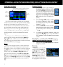
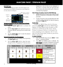
NAVCOM Page
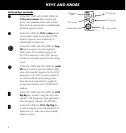
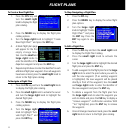
The NAVCOM page provides a list of the airport com-
munication and navigation frequencies at your departure,
en route and arrival airports.
Assigned
Frequency
Frequency
Category
Usage
Restriction
Information
Scroll Bar
Departure, En Route
or Arrival Airport
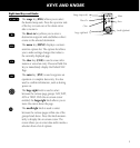
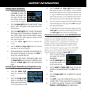
To Select a Frequency List for a Departure, En Route,
or Arrival Airport
1. Press the
small right
knob to activate the
cursor.
2. Turn the
large right
knob to place the cursor on
the airport identifier field (top line on the NAVCOM
page).
3. Turn the
small right knob to select the desired
airport and press
ENT.
To Scroll Through the List of Frequencies
1. Activate the cursor, if not already active, by pressing
the small right
knob.
2. Turn the
large right knob to move the cursor
through the list of frequencies. If there are more
frequencies in the list than can be displayed on
the screen, a scroll bar along the right-hand side
of the screen will indicate which part of the list is
currently being displayed.
Auto-Tuning a Frequency from the NAVCOM Page
1. Highlight the desired frequency by scrolling through
the list of frequencies, as described in the previous
procedure.
2. To place a frequency in the standby field of the COM
or VLOC window, highlight the desired frequency
and press the
ENT key.
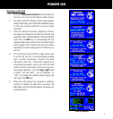
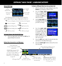
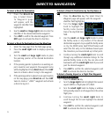
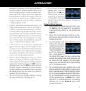
Terrain Page
To display the TERRAIN Page, select the NAV group
and turn the
small right knob until the TERRAIN Page is
displayed. The page displays terrain information, aircraft
ground track, and GPS-derived MSL altitude. Altitude
is shown in increments of 20 feet or in increments of 10
meters, depending on unit configuration. The “G” to the
right of the MSL altitude display reminds the pilot that the
altitude is GPS-derived.
To inhibit TERRAIN:
1. Select the TERRAIN Page and press
MENU
. “Inhibit
Terrain?” is selected by default.
2. Press
ENT. The TERRAIN system is inhibited. The
annunciation is displayed in the terrain
annunciator field whenever terrain is inhibited.
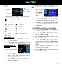
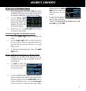
NAVCOM PAGE / TERRAIN PAGE
Obstacle Symbol
Unlighted Obstacle
Lighted Obstacle
Color
TERRAIN/Obstacle
Location
< 1000’ AGL
> 1000’ AGL < 1000’ AGL
> 1000’ AGL
Red
Terrain/Obstacle above or
within 100 ft below current
aircraft altitude
Yellow
Terrain/Obstacle between
100 ft and 1000 ft below the
aircraft altitude
Black
TERRAIN/Obstacle is more
than 1000 ft below the aircraft
altitude
Terrain Color Symbology