


2
Select a map.
Navigation Settings
To open the Navigation settings page, from the main menu,
select Settings > Navigation.
Calculation Mode: Sets the route calculation method.
Avoidances: Sets road features to avoid on a route.
Custom Avoidances: Allows you to avoid specific roads or
areas.
Environmental Zones: Sets the avoidance preferences for
areas with environmental or emissions restrictions that may
apply to your vehicle.
Toll Roads: Sets preferences for avoiding toll roads.
Tolls and Fees: Sets preferences for avoiding toll roads and toll
stickers.
NOTE: This feature is not available in all areas.
Restricted Mode: Disables all functions that require significant
operator attention and could become a distraction while
driving.
GPS Simulator: Stops the device from receiving a GPS signal,
and saves battery power.
Calculation Mode Settings
Select Settings > Navigation > Calculation Mode.
The route calculation is based on road speeds and vehicle
acceleration data for a given route.
Faster Time: Calculates routes that are faster to drive but can
be longer in distance.
Shorter Distance: Calculates routes that are shorter in distance
but can take more time to drive.
Less Fuel: Calculates routes that could use less fuel than other
routes.
Off Road: Calculates a direct line from your location to your
destination.
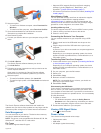
Setting a Simulated Location
If you are indoors or not receiving satellite signals, you can use
the GPS to set a simulated location.
1
Select Settings > Navigation > GPS Simulator.
2
From the main menu, select View Map.
3
Tap the map twice to select an area.
The address of the location appears at the bottom of the
screen.
4
Select the location description.
5
Select Set Location.
Bluetooth Settings
Select Settings > Bluetooth.
Bluetooth: Enables Bluetooth wireless technology.
Search for Devices: Searches for nearby Bluetooth devices.
Friendly Name: Allows you to enter a friendly name that
identifies your device on other devices with Bluetooth
wireless technology.
Disabling Bluetooth
1
Select Settings > Bluetooth.
2
Select Bluetooth.
Display Settings
To open the Display settings page, from the main menu, select
Settings > Display.
Color Mode: Sets the device to display day or night colors. You
can select Auto to allow the device to automatically set day or
night colors based on the time of day.
Brightness: Adjusts the display brightness.
Display Timeout: Sets the amount of idle time before your
device enters sleep mode.
Screenshot: Allows you to take a picture of the device screen.
Screenshots are saved in the Screenshot folder of the device
storage.
Traffic Settings
To open the traffic settings page, from the main menu, select
Settings > Traffic.
Traffic: Enables traffic.
Current Provider: Sets the traffic provider to use for traffic data.
Auto selects the best available traffic data automatically.
Subscriptions: Lists current traffic subscriptions.
Optimize Route: Selects whether to use optimized alternate
routes automatically or upon request (Avoiding Traffic Delays
on Your Route, page 5).
Traffic Alerts: Selects the traffic delay severity for which the
device displays a traffic alert.
Units and Time Settings
To open the Units and Time settings page, from the main menu,
select Settings > Units & Time.
Current Time: Sets the device time.
Time Format: Allows you to select a 12-hour, 24-hour, or UTC
display time.
Units: Sets the unit of measure used for distances.
Position Format: Sets the coordinate format and datum used
for geographical coordinates.
Setting the Time
1
From the main menu, select the time.
2
Select an option:
• To set the time automatically using GPS information,
select Automatic.
• To set the time manually, drag the numbers up or down.
Language and Keyboard Settings
To open the Language and Keyboard settings, from the main
menu, select Settings > Language & Keyboard.
Voice Language: Sets the language for voice prompts.
Text Language: Sets all on-screen text to the selected
language.
NOTE: Changing the text language does not change the
language of user-entered data or map data, such as street
names.
Keyboard Language: Enables keyboard languages.
Proximity Alerts Settings
NOTE: You must have custom points of interest (POIs) loaded
for proximity points alerts to display.
Select Settings > Proximity Alerts.
Audio: Sets the style of alert that plays when you approach
proximity points.
Alerts: Sets the type of proximity points for which alerts are
played.
Device and Privacy Settings
To open the device settings, select Settings > Device.
About: Displays the software version number, the unit ID
number, and information on several other software features.
EULAs: Displays the end-user license agreements.
Customizing the Device 17