


58 GPSMAP 400/500 Series Owner’s Manual
Using XM WX Weather and Audio
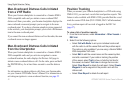
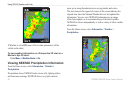
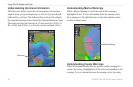
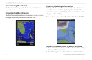
Understanding Hurricane Information
The Hurricanes feature shows the current position of a hurricane,
tropical storm, or tropical depression, as well as its projected path
(indicated by a red line). The darkened dots on the red line display
the projected locations received from the National Hurricane Center.
The center provides four forecasts at 12-hour intervals (12 Hrs, 24
Hrs, 36 Hrs, and 48 Hrs), as well as the current conditions (Now).
Hurricane
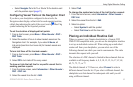
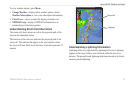
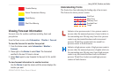
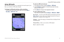
Understanding Marine Warnings
When a Marine Warning is issued, the area for the warning is
highlighted in red. To view information about the warning, select
the warning area. The light blue lines on the chart indicate marine
weather warning zones.
Marine Warning
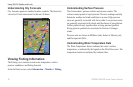
Understanding County Warnings
When the National Weather Service issues a weather warning for a
county, the county is highlighted with the color corresponding to the
warning. To view information about the warning, select the county.