


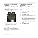

Appendix
Rino 650 Owner’s Manual 41
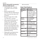
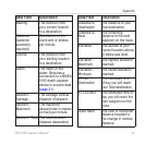
Data Field Description
Bearing The direction from
your current location
to a destination
Cadence
(cadence
accessory
required)
Revolutions of the
crank arm or strides
per minute
Course The direction from
your starting location
to a destination
Depth The depth of the
water Requires a
connection to a NMEA
0183 depth-capable
device to acquire data
(page 21)
Descent -
Average
The average vertical
distance of descent
Descent -
Maximum
The maximum
descent rate in meters
(or feet) per minute
Descent - Total The total elevation
distance descended
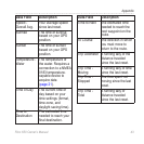
Data Field Description
Distance to
Destination
The distance to your
nal destination
Distance to
Next
The remaining
distance to the next
waypoint on the route
Elevation The altitude of your
current location above
or below sea level
Elevation -
Maximum
The highest elevation
reached
Elevation -
Minimum
The lowest elevation
reached
ETA at
Destination
The estimated time
of day you will reach
your nal destination
ETA at Next The estimated time of
day you will reach the
next waypoint on the
route
Glide Ratio The ratio of horizontal
distance traveled to
the change in vertical
distance