


5
2.3 Turning the Radar On/Off
Press the [POWER] key to turn the radar on or
off.
The control panel lights and a timer displays
the time remaining for warm up of the magne-
tron (the device which produces radar pulses),
counting down from 1:30 to 0:01.
2.4 Transmitting
After the power is turned on and the magnetron
has warmed up, STBY (Stand-By) appears at
the screen center. This means the radar is now
fully operational. In stand-by the radar is avail-
able for use at anytime - but no radar waves are
being transmitted.
Press the [STBY TX] key to transmit.
When transmitting, any echoes from targets
appear on the display. This radar displays ech-
oes in eight tones of green according to echo
strength.
2.5 Stand-by
When you won’t be using the radar for an ex-
tended period, but you want to keep it in a state
of readiness, place it in stand-by by pressing
the [STBY TX] key. The display shows
“STBY,” navigation data, or goes into the
economy mode depending on menu setting.
(More on menu operation later.)
Economy mode
The CRT can be set to automatically turn itself
off when in stand-by, to reduce power consump-
tion. This feature is called the “economy mode.”
Power consumption in the economy mode is 28
W. When the economy mode is on, the lamp
next to the [POWER] key lights.
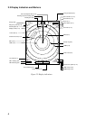
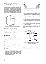
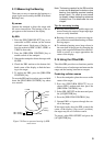
Navigation data display during
stand-by
If a navigation aid inputs navigation data to this
radar, navigation data can be displayed during
stand-by. You can turn the navigation data dis-
play on/off through the menu. Figure 2-3 shows
a typical navigation data display during stand-
by.
Figure 2-3 Typical navigation data display
during stand-by
Bearing TO Waypoint
N
SPEED
TRIP
DEPTH TEMPERATURE
10.5
kt
125
m
ST-BY
000.3 nm
+17.3
°C
HDG
092.5°
CRS 180.0°M
WPT TTG 01:08
BRG
RNG
45.0° M
12.0NM
OWN SHIP
LAT 30°00.00N
LON 135°00.00E
TD 36378.1
59096.4
XTE
R 0.3NM
E
S
W
L
R
XTE
XTE
Time-to-go to Stand-by
Trip distance since power on
Speed
Depth
To Waypoint
bearing Heading
Course
Heading
Time-to-go to
TO Waypoint
Range to TO Waypoint
Ship's position in
latitude and longitude
and Loran TDs
Cross Track Error
Mark " " shows
direction and amount
of error.
1.0
0.5
0.5
1.0