


2
Horizon NavMate 5
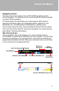
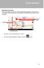
position on the surface of the planet. Using these distance measurements, the
receiver might also be able to calculate speed, bearing, trip time, distance to
destination, altitude, etc. The GPS position may be displayed as a point on a
digital map (at least three satellites' signals must be received) and as the GPS
device moves the corresponding trace is displayed as well.
Please keep in mind that although the radio signals of navigation satellites will
pass through clouds, glass, plastic, and other lightweight materials, satellite-
navigation receivers will not work underground or in some enclosed spaces.
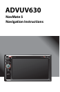
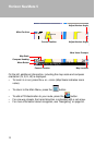
Horizon NavMate Navigation / Tele Atlas Map Data
The ADVUV630 is pre-loaded with Horizon NavMate 5 and Tele Atlas map
data. The map data covers the continental US.
The initial GPS location lock is best established when your vehicle is parked.
If the device is in motion, the signal can take longer to initially connect. Once
the initial coordinates are established, the software will follow you as you
move and navigate.
NOTE: It may take up to 5 minutes to establish the first connection.
Subsequent connections will be faster (30 seconds to 1 minute), but if you
have not used the unit for several days or are very far away from the last
location you used it, it may take up to 5 minutes again to find a strong signal.