


12
13
Fort Jay
Gove
rnors
Island
Hoboken
Holland T
unnel
Br
o
a
dw
ay
FD
R
Dr
S
F
DR Dr
N
FD
R
D
r
S
1s
t
Av
e
3r
d
A
ve
Brooklyn
Brooklyn
Height
s
Fort
Greene
Greenwich
Vi
llage
13th
S
t
We
s
t St
W
es
t St
14t
h
S
t
Wi
ll
i
amsbur
g Br
i
d
ge
E
H
o
us
to
n
S
t
Hud
son St
New York
Av
e
n
u
e
S
Broo
k
l
yn
Br
i
d
ge
Chinatown
Canal St
Gr
a
nd
St
E
B
road
wa
y
Manhat
t
an
B
ri
d
ge
Br
o
ok
lyn
B
at
t
er
y T
unnel
ve
ve
1
W
es
t St
W
es
t S
t
G
Governors
and
Island
unnel
unnel
Manhattan
New York
n
n
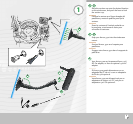
Lock
�
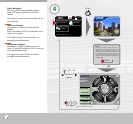
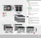
Options concernant la carte
Côté gauche:
Pour afficher ces options il faut d’abord que
l’option ‘Zoom & Rotation’ soit activée dans le
menu rapide. Vous pouvez ensuite zoomer en
avant ou en arrière. Et également effectuer une
rotation de la carte. Vous modifiez ainsi l’angle
de vue vertical de la carte. Vous passez d’une
vue en 2D à une vue en 3D de façon à voir plus
loin.
Côté droit:
Fleche noire – Direction de la voiture
La flèche (l’avant de la voiture) est dirigée vers
le haut et reste en haut. La carte tourne sous
la flèche.
Flèche blanche - Nord en haut
La carte est affichée avec la direction Nord
en haut de l’écran. La flèche (direction de la
voiture) tourne.
Avion – Vue d’en haut
Pour afficher une vue d’avion de la carte.
Indication de la force du signal satellite, de
la capacité de la batterie et du son allumé ou
éteint.
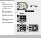
Opciones de mapa
Lado izquierdo:
Estas opciones de mapa sólo se muestran
si se ha activado “Zoom e inclin” (Zoom y
Desplazar) en el Menú rápido. Entonces podrá
ampliar y reducir.
También podrá desplazar el mapa.
Con ello podrá cambiar el ángulo de visión
vertical del mapa. El mapa cambia de vista 2D
a vista 3D para que pueda verlo mejor.
Lado derecho:
Flecha negra - Dirección de conducción
La flecha (parte delantera del coche) señala
arriba y se mantiene en esta posición.
El mapa gira debajo de la flecha.
Flecha blanca - Norte en la parte superior
El mapa se sitúa de modo que el Norte siempre
está en la parte superior de la pantalla. La
flecha (dirección de conducción) gira.
Avión - Vista aérea
Se muestra una vista aérea del mapa.
Indicador de nivel de señal del satélite,
capacidad de la batería y sonido conectado
o desconectado.
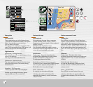
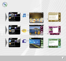
Map options
Left-hand side:
These map options are only displayed when
“Zoom & Tilt” has been activated in the Quick
Menu. You can then zoom in and out.
You can also tilt the map.
This changes the vertical viewing angle of the
map. The map switches from a 2D view to a 3D
view so that you can see further ahead.
Right-hand side:
Black arrow – Driving direction
The arrow (front of the car) points upwards and
stays in this position.
The map turns underneath the arrow.
White arrow - North at the top
The map is positioned so that North is always
at the top of the screen. The arrow (driving
direction) turns.
Aeroplane – Bird’s-eye view
A bird’s-eye view of the map is displayed.
Satellite signal strength indicator, battery
capacity and sound on or sound off.