


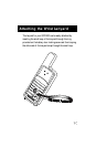


39
Landmark A location saved in the unit’s memory which
is obtained by entering data, editing data,
calculating data or saving a current position.
Used to create routes.
Latitude The angular distance north or south of the
equator measured by lines encircling the earth
parallel to the equator in degrees from 0° to
90°.
LAT/LON Coordinate system using latitude and longi-
tude coordinates to define a position on the
earth.
Leg (Route) A segment of a route that has a starting
(FROM) landmark and a destination (TO)
landmark. A route may consist of 1 or more
legs. A route that is from landmark A to
landmark B to landmark C to landmark D has
three legs with the first being from landmark
A to landmark B.
Longitude The angular distance east or west of the prime
meridian (Greenwich meridian) as measured
by lines perpendicular to the parallels and
converging at the poles from 0° to 180°.
Magnetic North The direction toward the north magnetic pole
from the observer’s position.
Position Fix Position coordinates as computed by the
GPS 300.