


9400-series User Manual Page 7
3 Map Screen
The most commonly used screen is the Map
screen. Whether you are following a route or
just traveling around a city, the chances are
that the Map screen will be displayed. The Map
screen can be displayed in two distinct modes:
normal and routing.
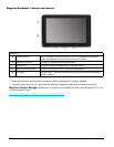
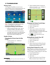
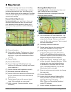
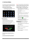
Normal Mode Map Screen
In normal mode, your position is shown on
the map along with the time. As you travel,
your position will be updated, giving you a
clear view of your position and surrounding
streets.
(A) Current location.
(B) Information display. Displays your choice
of speed, time of day, elevation, compass
direction. Tap on the information field to
change.
(C) Zoom Out/In.
(D) Access Main Menu.
(E) Access Highway POIs (Displayed only
while on an Interstate, freeway, and some)
state highways.)
(F) Access volume and brightness controls.
(G) Bluetooth (selected models only)
(H) Access OneTouch Menu for instant access
to your saved search criteria and favorite
destinations.
(I) Posted speed limit on the current travel
road. (Not available on every road.)
(J) Traffic in vicinity. (Selected models, when
available.)
A
C
D
E
F
G
H
B
J
I
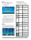
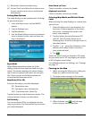
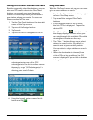
Routing Mode Map Screen
In routing mode, a destination has been set
and a route has been calculated.
Detailed information is displayed about the
route you have selected.
(A) Turn instructions for next maneuver. Tap
icon to display the maneuver list (available
only when routing). Distance and road
name for the next maneuver. Tap to repeat
last voice instruction.
(B) Following maneuver indicator.
(C) Posted speed limit on the current travel
road. (Not available on every road.)
(D) Traffic delay on current route. Red if
projected delay more than 15% of trip
time. Tap for additional information and
avoidance options. (Selected models, with
Magellan-supplied power adapter.)
(E) Information display. Displays speed, time
of day, elevation, compass direction. While
routing it also can also display distance
to destination, estimated time of arrival
(ETA), and time remaining. Tap on the
information field to change.
(F) Zoom in and zoom out controls to change
the map scale.
(G) Access Main Menu.
(H) Access the list of nearest Highway Exit
POIs (available only when driving on a
highway/freeway/interstate).
Note: These can be enabled/disabled
under POI settings.
(I) Access volume, brightness controls.
F
E G
H
I
A
C
D
B
K
J