


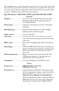
4
Transmitter:....................3,000 watts peak-to-peak/375 watts RMS.
Sonar sounding
depth capability:............LMS-527cDF: 2,500 feet/762 meters.
LMS-522c: 1,000 feet/305 meters.
(Actual capability depends on transducer
configuration and installation, bottom com-
position and water conditions. All sonar
units typically read deeper in fresh water
than in salt water.)
Depth display: ................Continuous display.
Graph recording:...........Up to 1 GB on one MMC (or SD) card
Audible alarms:..............Deep/shallow/fish/zone.
Automatic ranging: .......Yes, with instant screen updates.
Auto bottom track: ........Yes
Zoom bottom track:.......Yes.
Split-screen zoom: .........Yes.
Surface water temp: .....Yes, built into transducer.
Speed/distance log: .......Yes, with optional speed sensor (sensor in-
cluded with LMS-527cDF.)
GPS
Receiver/antenna:............Internal; Built in 12 parallel channel NMEA
2000-ready GPS/WAAS receiver/antenna.
Background map: ..........Built-in custom, detailed Lowrance map.
Contains: enhanced detail of continental U.S.
and Hawaii. Includes more than 60,000 nav
aids and 10,000 wrecks/obstructions in
coastal and Great Lakes waters. Metro ar-
eas, selected major streets/highways and in-
terstate exit services details included.
Custom mapping:...........MapCreate
™
6 software optional; optional
plug and play LEI FreedomMaps™ offer the
same high-detail without the computer work
of MapCreate. Other plug and play mapping
options include IMS™ Fishing Hot Spots
®
,
LEI NauticPaths™ charts and Navionics
®
charts.