


30 GPS Navigation Instruction Manual
Traffic Information
Using the built-in receiver, the navigation system can receive and use traffic information. When a traffic
message is received, you can see the event on the map and change your route to avoid the traffic incident.
Traffic information is not available on all models or in all areas.
NOTICE
Garmin and JVC KENWOOD is not responsible for
the accuracy or timeliness of the traffic information.
Traffic information may not be available in all areas
or countries.
Traffic Subscription Activation
You do not need to activate the subscription
included with your navigation system. The
subscription activates automatically after your
system acquires satellite signals while receiving
traffic signals from the pay service provider.
Understanding Traffic
Your navigation system can receive traffic
information using the built-in traffic receiver or
a traffic subscription from Garmin Live Services
(page 25). The traffic receiver must be in data
range of a station transmitting traffic data to
receive traffic information. The traffic subscription
activates automatically after your navigation
system acquires satellite signals while receiving
traffic signals from the service provider. You
can add other subscriptions at any time. For
information about traffic receivers and coverage
areas, go to www.garmin.com/kenwood.
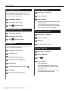
Traffic Data Using Smartphone Link
You can purchase a traffic subscription to receive
traffic data using Smartphone Link. When your
navigation system is connected to Smartphone
Link and within a traffic coverage area, your
system will begin displaying traffic information.
Traffic data is not available in all areas.
1 From your phone, purchase a traffic
subscription from Garmin Live Services
(page 25).
2 Connect your device to Smartphone LInk
(page 24).
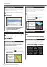
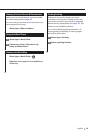
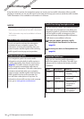
About the Traffic Icon
When you are receiving traffic information, a
traffic icon appears on the Map. The traffic icon
changes color to indicate the severity of traffic
conditions.
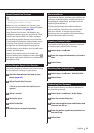
Color Description Meaning
Green Low severity Traffic is flowing
normally.
Yellow Medium
severity
Traffic is slightly
congested.
Red High severity Traffic is heavily
congested or
stopped.
Gray No data Traffic data has
not updated.