


54
Reference
Routes
Creating a New Route
Pointing To a Starting Point To Start a Route
Although the StreetPilot does not automatically give turn-by-turn directions when a destination
is chosen, you can select your starting point and your destination and then manually select a route by
choosing the roads and streets you wish to travel. After you have “built a route” you will see turn-by-
turn directions. To demonstrate a route, plan a trip from Madrid, Spain to the city of Bacelona in in the
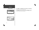
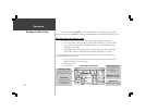
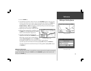
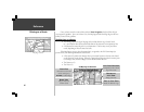
same country. As you are creating and editing routes, the top of the screen prompts you for what to do
next (see bottom left picture).
To create a new route:
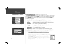
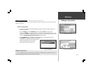
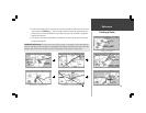
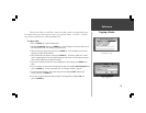
1. Press the ROUTE key to view the Route menu.
2. Highlight Create New Route (top left picture) and press the ENTER key. The
screen shows a full-screen map with a panning arrow.
3. Use the ROCKER keypad to point to the desired starting point for the route ( bottom left
picture). It is often desirable to highlight a map object for the route starting and ending
points, although it is not necessary. Remember you can use the Zoom IN and OUT keys to
quickly pan around the map. Press the ENTER key to accept the starting point.
OR
Press the FIND key, and find a Personal Waypoint, City, Point of Interest, Address or Intersection
to use as the starting point of the route (Find Functions are described on pages 41-51). Once
the information page is displayed for the item you found, highlight Add to route and press the
ENTER key.
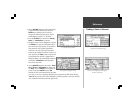
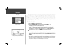
4. Repeat step 3 to set the desired destination for the route (top right picture on the following
page). The total route distance (point to point) is shown in the lower right corner of the screen
(first picture in sequence on the following page). This distance will change to reflect the actual
driving distance when you have completed adding turns to the route.