


Data Management
You can store files on your device. The device has a memory
card slot for additional data storage.
NOTE: The device is not compatible with Windows
®
95, 98,
Me, Windows NT
®
, and Mac
®
OS 10.3 and earlier.
File Types
The device supports these file types.
• Maps and GPX waypoint files from myGarmin™ mapping
software, including MapSource
®
, BaseCamp™, and
HomePort™ (page 4).
• GPI custom POI files from Garmin POI Loader (page 4).
About Memory Cards
You can purchase memory cards from an electronics supplier,
or purchase pre-loaded Garmin mapping software
(www.garmin.com/trip_planning). In addition to map and data
storage, the memory card can be used to store files such as
maps, images, geocaches, routes, waypoints, and custom
POIs.
Installing a Memory Card
The device supports microSD™ and microSDHC memory cards.
1
Insert a memory card into the slot on the device.
2
Press it in until it clicks.
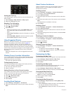
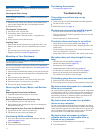
Connecting the Device to Your Computer
You can connect the device to your computer using the USB
cable included with your device.
1
Plug the small end of the USB cable into the port on the
device.
2
Plug the larger end of the USB cable into a port on your
computer.
A picture of your device connected to a computer appears on
the device screen.
Depending on your computer operating system, the device
appears as either a portable device, a removable drive, or a
removable volume.
Transferring Data From Your Computer
1
Connect the device to your computer (page 12).
Depending on your computer operating system, the device
appears as either a portable device, a removable drive, or a
removable volume.
2
On your computer, open the file browser.
3
Select a file.
4
Select Edit > Copy.
5
Browse to a folder on the device.
NOTE: For a removable drive or volume, you should not
place files in the Garmin folder.
6
Select Edit > Paste.
Disconnecting the USB Cable
If your device is connected to your computer as a removable
drive or volume, you must safely disconnect your device from
your computer to avoid data loss. If your device is connected to
your Windows computer as a portable device, it is not
necessary to safely disconnect.
1
Complete an action:
• For Windows computers, select the Safely Remove
Hardware icon in the system tray, and select your device.
• For Mac computers, drag the volume icon to the trash.
2
Disconnect the cable from your computer.
Customizing the Device
Map and Vehicle Settings
To open the Map and Vehicle settings, from the main menu,
select Settings > Map & Vehicle.
Vehicle: Changes the icon to represent your position on the
map. Go to www.garmingarage.com for more icons.
Driving Map View: Sets the perspective on the map.
Map Detail: Sets the level of detail on the map. More detail may
cause the map to draw slower.
Map Theme: Changes the color of the map data.
Map Tools: Selects the shortcuts that appear in the map tools
menu.
Map Layers: Sets the data that appears on the map page
(page 6).
myMaps: Sets which installed maps the device uses.
Enabling Maps
You can enable map products installed on your device.
TIP: To purchase additional map products, go to
www.garmin.com/us/maps.
1
Select Settings > Map & Vehicle > myMaps.
2
Select a map.
Navigation Settings
To open the Navigation settings page, from the main menu,
select Settings > Navigation.
Calculation Mode: Sets route preference.
Avoidances: Sets road features to avoid on a route.
Custom Avoidances: Allows you to avoid specific roads or
areas.
Advanced Detours: Sets the length of the detour.
Safe Mode: Disables all functions that require significant
operator attention and could become a distraction while
driving.
GPS Simulator: Stops the device from receiving a GPS signal,
and saves battery power.
Route Preferences
To open the Calculation Mode settings page, from the main
menu, select Settings > Navigation > Calculation Mode.
The route calculation is based on road speeds and vehicle
acceleration data for a given route.
Faster Time: Calculates routes that are faster to drive but can
be longer in distance.
Shorter Distance: Calculates routes that are shorter in distance
but can take more time to drive.
Less Fuel: Calculates routes that could use less fuel than other
routes.
Off Road: Calculates a direct line from your location to your
destination.
Display Settings
To open the Display settings page, from the main menu, select
Settings > Display.
Color Mode: Changes the brightness of the screen. Decreasing
the brightness can save battery power.
Display Timeout: Sets the amount of idle time before your
device enters sleep mode.
Brightness: Adjusts the display brightness.
Screenshot: Allows you to take a picture of the device screen.
Screenshots are saved in the Screenshot folder of the
device storage.
12 Data Management