


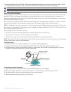
8 GPSMAP 400/500 Series Installation Instructions
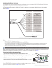
Connecting the Wiring Harness to a Garmin CANet Device
If your GPSMAP 400/500 series chartplotter is Garmin CANet-compatible, it can receive sonar information from a CANet-compatible Garmin
Sounder or Fishnder device. See the chartplotter functionality matrix on page 1 to determine whether your chartplotter is CANet compatible.
Using the CANet optimizes the performance of CANet-compatible devices, allowing sonar information from a sounder or shnder to be
shared with up to two CANet compatible Garmin chartplotters. A standard NMEA 0183 connection only allows depth, temperature, and speed
information to be sent to a single chartplotter, whereas a CANet connection provides full sonar readings, including Ultrascroll
™
, so you can
view and control the same information on your compatible chartplotter(s) as you can on your compatible Garmin sounder or shnder.
NOTE: To use the Garmin CANet with your device, you must purchase an optional CANet Kit. Contact your Garmin dealer, or visit
www.garmin.com.
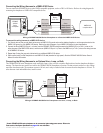
Connecting the Chartplotter to a NMEA 2000 Network
If your GPSMAP 400/500 series chartplotter is NMEA 2000-compatible, you can connect it to an existing NMEA 2000 network on your boat
to share information with other connected NMEA 2000-compatible devices. If you do not have an existing NMEA 2000 network on your boat,
you will need to build one. See www.garmin.com for more information.
NOTE: NMEA 2000-compatible GPSMAP 400/500 series chartplotters are not packaged with NMEA 2000 connectors or cables. You will need
a NMEA 2000 T-connector and drop cable to connect it to an existing NMEA 2000 network. NMEA 2000 components are available from your
local Garmin dealer or marine dealer.
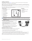
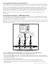
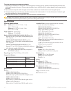
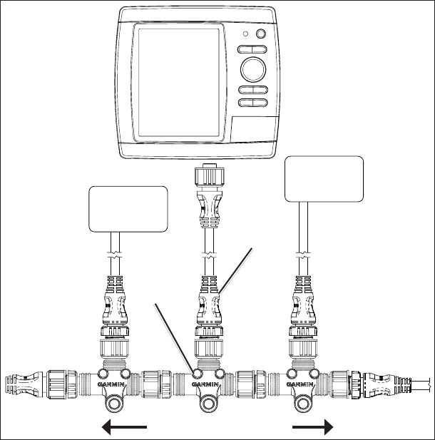
Connecting a NMEA 2000-compatible GPSMAP 400/500 Series
Chartplotter to an Existing NMEA 2000 Network
Existing NMEA 2000 network
Drop cable
(not included)
T-connector
(not included)
NMEA 2000
device
(not included)
NMEA 2000
device
(not included)
NMEA 2000-
compatible
GPSMAP
400/500 series
chartplotter
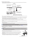
To connect a NMEA 2000-compatible GPSMAP 400/500 series chartplotter to your existing NMEA 2000 network:
1. DetermineanappropriatelocationtoconnectthechartplottertoyourexistingNMEA2000network.
2. Disconnect one side of a NMEA 2000 T-connector from the backbone nearest to the location where you want to connect the chartplotter.
IfyouneedtoextendtheNMEA2000backbone,connectanappropriateNMEA2000backboneextensioncable(notincluded)tothesideof
the T-connector you disconnected.
3. Add a T-connector (not included) to the NMEA 2000 backbone.
4. Route a NMEA 2000 drop cable from the chartplotter to the top of the T-connector you added to your NMEA 2000 network.
Youcanuseadropcableupto20ft.(6m).Ifmorecableisneeded,addanextensiontoyourNMEA2000backbone,basedonthe
NMEA 2000 guidelines.