


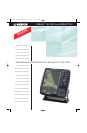

GPSMAP
®
182/182C and GPSMAP
®
232
©
2001 GARMIN Corporation
GARMIN International
1200 East 151st Street
Olathe, Kansas 66062, U.S.A.
913/397.8200 fax 913/397.8282
GARMIN (Europe) Ltd.
Unit 5, The Quadrangle
Abbey Park Industrial Estate
Romsey, SO51 9AQ, U.K.
44/1794.519944 fax 44/1794.519222
GARMIN (Asia) Corporation
No. 68, Jangshu 2nd Rd.
Shijr, Taipei County, Taiwan
886/2.2642.9199 fax 886/2.2642.9099
www.garmin.com
Specifications are preliminary and subject to change
without notice.
*
Subject to accuracy degradation to 100m
2DRMS under the U.S. Department of Defense
imposed Selective Availability Program.
Plotter/moving map features
Basemap: Built-in worldwide basemap to 32 nm with
coastlines, rivers, lakes, political boundaries,
tide data for the U.S., cities and interstates
Data cartridges: Preprogrammed micro cartridges containing
detailed BlueChart
™
marine cartography
Power
Source: 8-35v DC
Usage: 4 watts max. at 13.8v DC
Physical
Size: GPSMAP 182/182C = 6.3" W x 6.2" H x 2.6" D
GPSMAP 232 = 7.7" W x 7.5" H x 2.6" D
Weight: GPSMAP 182/182C = 1.7 lbs. (.77 kg)
GPSMAP 232 = 2 lbs. (.91 kg)
Display: GPSMAP 182 = 5.5" diagonal (14.0 cm)
high-resolution, 10-level grayscale LCD
with backlighting (240 x 360 pixels)
GPSMAP 182C = 5.0" diagonal (12.7 cm)
16-color TFT display with backlighting
(234 x 320 pixels)
GPSMAP 232 = 7.1" diagonal (18.0 cm)
high-resolution, 10-level grayscale LCD
with backlighting (240 x 360 pixels)
Case: Fully gasketed, high impact plastic alloy,
waterproof to IEC 529 IPX7 standards
Temp. range: 5ºF to 158ºF (-15ºC to 70ºC)
Accessories
Standard: Power/data cable
Bail mount
Protective front cover
Remote antenna with 30' cable
Owner’s manual
Quick reference guide
Optional: Preprogrammed data cards with
BlueChart
™
marine cartography
AC/PC adapter
12-volt adapter cable
USB data card programmer
Second mounting station
GBR 23 beacon receiver
MapSource
™
CDs:
Fishing Hot Spots
®
U.S. Waterways & Lights
Roads & Recreation
WorldMap
Navigation features
Waypoints/icons: 3000 with name, symbol and comments;
support for proximity waypoints
Routes: 50 reversible routes up to 50 (254 for 182C)
points each, plus MOB and TracBack
®
modes
Track log: 3000 point automatic track log, 15 saved
tracks; 500 points per saved track, lets
you retrace your path in both directions
Alarms: Anchor drag, arrival, off course,
proximity waypoint and clock
Tables: Built-in celestial tables with sun and moon
rise, set and location. Tide tables for the U.S.
Map datums: More than 100, plus user datum
Position format: Lat/Lon, UTM/UPS, Loran TDs and other
grids, including user grid
Languages: 10
GPS performance
Receiver: WAAS enabled, 12 parallel channel GPS
receiver continuously tracks and uses up
to 12 satellites to compute and update
your position
Acquisition times:
Warm: Approximately 15 seconds
Cold: Approximately 45 seconds
AutoLocate
™
: Approximately 5 minutes
Update rate: 1/second, continuous
GPS accuracy:
Position: < 15 meters, 95% typical*
Velocity: 0.05 meter/sec steady state
DGPS (USCG) accuracy:
Position: 3-5 meters, 95% typical
Velocity: 0.05 meter/sec steady state
DGPS (WAAS) accuracy:
Position: 3 meters, 95% typical
Velocity: 0.05 meter/sec steady state
Dynamics: 6g’s
Interfaces: 2-RS232 with NMEA 0183, RTCM 104 DGPS
data format and proprietary GARMIN
Antenna: GPSMAP 182 = GA 29 remote marine mount
with 30' cable or bail mount antenna
GPSMAP 232 = GA 29 remote marine mount
with 30' cable
REV1101 M01-10113-00
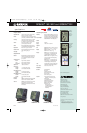
GPSMAP 182 GPSMAP 182CGPSMAP 232
specifications
The graphic
pointer helps
you stay on
course to your
destination.
The big numbers
option makes
data fields
readable from
a distance.
Tide charts
display detailed
tide data for
the U.S.
MRN/12495 182/182C/232SpSh.lyt 11/12/01 3:07 PM Page 2