


77
14. Magnetic Variation Options
Magneticvariationhasbeensimpliedtothechoices
ofMagneticandTrue.
See the section on Units/Position of the Setup 1 Page in
the Aux Pages chapter of the Pilot’s Guide for more details.
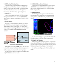
15. Terrain Database
TheTerrainfunctioninNavmodeisnowastandard
feature.Theextensivedatabaseaidsinterrainawareness.
TAWSremainsasanoptioninthe500Wseries.
See the section on Terrain Operation in the Nav Pages
chapter of the Pilot’s Guide for more details.
16. Dead Reckoning (DR)
Deadreckoningistheprocessofcontinuingnavi-
gationbasedonyourlastknownpositionusingyour
currentheading,speed,time,anddistancetobetraveled
afteralossofGPSnavigationonanactiveightplan.
Navigationusingdeadreckoningisthereforeonlyan
estimateandrequiresthatyoumaintainthecourseand
speedshownonyour400W/500Wunit.Deadreckoning
shouldnotbeusedifanyothermeansofnavigationis
available,suchasaVORorpilotage.
DeadreckoningbecomesactiveafteralossofGPS
positionwhileyouarenavigatingusinganactiveight
plan.Apop-upmessagewillappearandrequirespilot
inputtoclearthemessage.Deadreckoningisnotavail-
ableifyouareinterminalorapproachmodes.
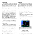
WhenDeadReckoningisactive,theownshipicon
colorischangedtoyellowandtheTo/Fromagis
removedfromtheCDI.TheDeadReckoningannun-
ciator(DR)appearsontheleftsideofthemapdisplay
whenGPSpositionisunavailableandtheunitisinDead
Reckoningmode.Allexternaloutputsdependenton
GPSpositionareagged.
See the section on Dead Reckoning in the Nav Pages
chapter of the Pilot’s Guide for more details.
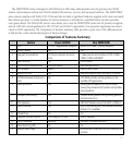
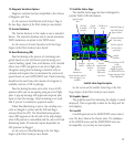
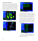
17. Satellite Status Page
TheSatelliteStatuspagehasbeenredesignedto
provideWAASGPSinformation.
Satellite Status Page Description
GPS Receiver
Status
Sky View
of satellite
positions
Signal Strength
Bars
Satellite
Numbers
Horizontal Figure of
Merit and Vertical
Figure of Merit
Estimated Position
Uncertainty
Acquiring
Satellite, not
ready for
use
Excluded
Satellite
Satellite acquired
but not used for
position fix
Satellite
acquired, used
for position
fix, and has
differential
corrections
“INTEG”
Annunciator
shown when the required
level of integrity is not
available
Current Page in NAV
Group
(page position
depends on options;
see 400W/500W Series
Display Interfaces Pilot's
Guide Addendum)
Current
UTC Time
See the section on the Satellite Status Page in the Nav
Pages chapter of the Pilot’s Guide for more details.
18. Graphics Speed
Thegraphicsspeedforredrawingthedisplayismuch
improved.ThisisespeciallyevidentontheMapandTer-
raindisplays.
19. Crossfill
Crosslloperationinthe400W/500Wseriesunitsis
now12xfasterthanintheClassicunits.Thedatabases
ofthe400/500seriesandthe400W/500Wseriesare
incompatible,soyoumaynotmixsystems.