


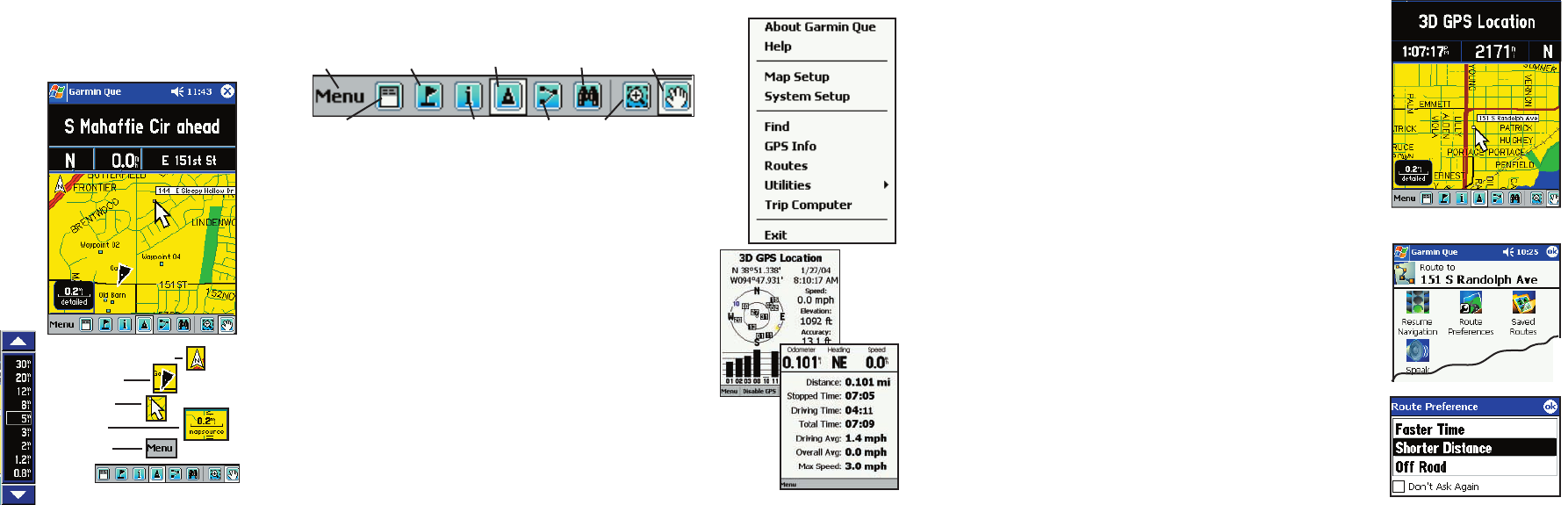
Navigating to a Destination
A destination can be determined in two ways: you use the
Map Pointer to mark a point on the map and then tap the
Routes icon... or use the Find Feature to search for a destination
from the map database and then, when found and highlighted,
choose the “Route To It” option from the Find Options Menu.
Using the Map Pointer:
1. Tap the point on the Map Page that you want to navigate to. If
there is information about that point in the map database, it will
display next to the point.
2. Then tap the Routes icon to display the Routes Page.
3. Tap the “Route To” fi eld and the route will begin to calculate.
4. A pop-up window will offer three preferences for calculating the
route. Select an option and tap OK to return to the Map Page to
complete calculation.
5. When the calculation is complete, the route will display as a
purple overlay on top of the map.
6. The fi rst maneuver on your route is displayed at the top of the
map page and is complemented by a voice prompt.
7. To view all of the turns on the route, open the Routes Page and
tap the Turns Page icon. A list of the turns will display and a
preview page for each turn will display when the turn on the list is
tapped.
Route Calculation Preferences Menu
Routes Page and “Route To”
Show/Hide Data Fields
Main Menu
Mark Waypoint FindCenter on Vehicle
Drag Box to ZoomRoutesDetails
Drag Map to Pan
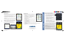
Navigation using the Map Page
Navigation is the process of going from your current location
to another, and the Map Page has features to help you do that.
Data Fields - Provide GPS Status when not moving, Direc-
tion of Travel or Next Street Ahead, Compass Direction, Speed
and Current Location
Map Detail -
With downloaded detailed maps: Residen
tial
Streets, Rivers, Lakes, Points of Interest and Individual Ad-
dresses. Oriented with North Up unless in Track Up mode.
The Position Arrow - Indicates your current location. Tap
to center it on the map page. Points in the direction of travel.
The Map Pointer - Marks map locations using the
stylus. Displays information for a location if available.
The Map Scale - Tapping the Map Scale Box in the
lower left corner of the map displays the moving Map
Scale. Tap the arrows to move up or down the scale.
Tap the desired scale to close.
Map Scale
The Map Page and its features:
Data Fields for Direction and Status,
Speed and Current Location
North Orientation Arrow
Position Arrow
Map Pointer
Map Scale
Main Menu
Tool Bar
The Tool Bar - Quick ways to get things done. Tap the icon to
get the result shown below.
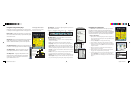
The Main Menu - Tap the Main Menu on the tool bar to
access every Garmin Que feature.
About Garmin Que - Tells you the version of operating software
and your unit id number.
Help - Provides information about the application operation.
Map Setup - Allows you to customize the way your maps display.
System Setup - Allows you to adjust system operating features.
Find - Allows you to search for and navigate to locations in the map
database, arranged by categories. More about this on the next
page.
GPS Info - Provides current information about the GPS receiver and
satellites overhead.
Routes - Allows you to calculate, manage, modify and save a route
to a selected destination.
More about this on the next
page.
Utilities -
Track Log, Sun & Moon, Hunt & Fish, and Measure Distance.
Trip Computer - Displays current information about your travel sta-
tus, such as distance, speed, driving time, driving average and more.
The Main Menu
The GPS
Info
Page
The Trip Computer
Destination Highlighted by the
Map Pointer
cf Q QS Review Format.indd 2 2/26/2004, 4:14:06 PM