


65
eTrex Vista C
GPS Navigation
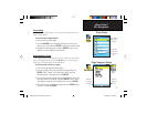
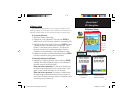
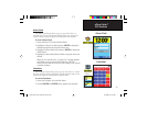
Altimeter Setup
Altimeter Setup
The Altimeter Setup Page allows you to setup the Altimeter to self-
calibrate each time you turn on the unit, to function as a barometer or to
manually calibrate when you have accurate elevation or pressure data.
To set up the Altimeter:
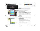
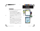
1. Access the Altimeter Setup Page.
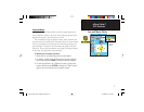
2. Highlight the “Auto Calibration” fi eld and press ENTER to
select from On or Off. When On, elevation is corrected by GPS.
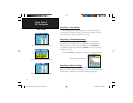
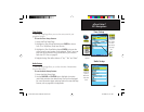
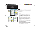
3. Highlight the Barometer Mode fi eld and press ENTER to select
“Variable Elevation” (used when you are moving) or “Fixed
Elevation” (used when you are stationary. This allows the
Altimeter to function as a standard barometer). Elevation
trip data is not recorded when in the Fixed Elevation mode.
4. Highlight the Pressure Trend Recording fi eld and press ENTER
to select a method for saving pressure trend data.
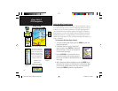
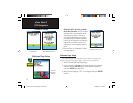
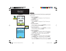
To manually calibrate the Altimeter:
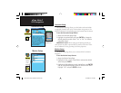
1. Highlight the “Calibrate Altimeter” button and press ENTER
to display the Calibrate Altimeter Page. You can calibrate the
Altimeter using one of three methods:
Enter the correct elevation: this requires a reliable source
for determining the elevation for your current location. Topo-
graphic maps, scientifi c altimeters, etc. can be used.
Enter the correct pressure: this requires a reliable source
for determining the accurate barometric pressure at your cur-
rent location. Scientifi c barometer, data from a weather station
in proximity to your location, etc.
Enter the correct
elevation
Enter the correct
barometric pressure
Barometer Mode Options
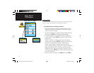
Saves every
15 minutes
when the unit
is powered
Off.
eTrex Vista C Owner's Manual Text.indd 65 8/12/2004, 9:17:45 AM