


5
5. GPS Position Calculation Rate
The WAAS GPS receiver calculates its position five
times per second rather than once per second like the
Classic C-129/C-129a GPS systems. This, together with
the enhanced vertical accuracy and other system en-
hancements, allows for vertical approach guidance.
6. GPS Software
The GPS software of the Classic 400/500 series met
the requirements for Level-C. The new 400W/500W
meets the more rigorous requirements of Level-B, where
required.
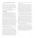
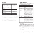
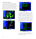
7. Vectors-To-Final
Auto-Suspend (SUSP) is active for Vectors To Final
(VTF) until on the “TO” side of the FAF and the aircraft
ground track is within a 45° course of the published in
bound course. At this point, the suspend annunciator
will automatically extinguish.
MAP
FAF
45°
45°
SUSP
On
SUSP
Off
Vector-To-Final
SUSP
On
SUSP
Off
Vector-To-Final Suspend Operation
Remember, don’t press OBS or you will have to
reload the approach, unless you desire to sequence to the
final approach segment in the active flight plan.
See the section on Vectors to Final in the Procedures
chapter of the Pilot’s Guide for more details.
8. GPS/WAAS-Based Vertical Guidance
The WAAS GPS receiver now allows you to use the
400W/500W series unit for primary navigation and
use GPS with vertical guidance for LPV, L/VNAV, and
LNAV+V approaches.
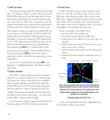
9. Holding Patterns
The Holding pattern depiction on the Nav mode
moving map shows the aircraft position and provides
active guidance, with roll steering autopilot-equipped
aircraft.
Guidance provided along the holding pattern
See the section on Flying an Approach with a Hold in the
Procedures chapter of the Pilot’s Guide for more details.
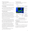
10. Autopilot Roll Steering
Roll steering guidance is now provided for procedure
turns and holding patterns. The holding pattern now de-
picts the actual location and shape of the holding pattern
while providing real-time display of your position.
See the Procedures chapter of the Pilot’s Guide for more
details.