


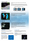
Past
positions
Vector shows trend
of movement.
Initial stage
Steady tracking
CPA alarm
Lost target
(Flashing)
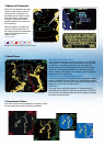
Past Position Display
The ARPA displays equally time-spaced dots
marking the past positions of any targets being
tracked. A new dot is added during preset time
intervals until the preset number is reached. AIS
also displays past position dots.
s
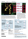
ARPA/AIS
Target automatically
acquired
AIS-equipped target
selected for data reading
Water temp,
Depth,
Wind
DATA Cell 1
AIS information
DATA Cell 2
Tracking data
DATA Cell 3
Tracking data
Target Association (Fusion)
An AIS-equipped ship may be shown on the display by both AIS and
ARPA symbols. This happens because the AIS position is measured
by a GPS navigator in L/L while the ARPA target blip and data are
measured by range and bearing from own ship. When the symbols are
within an operator-set criteria, the ARPA symbol is merged into the AIS
symbol. The criteria is determined by the differences in range, bearing,
course, speed, etc.
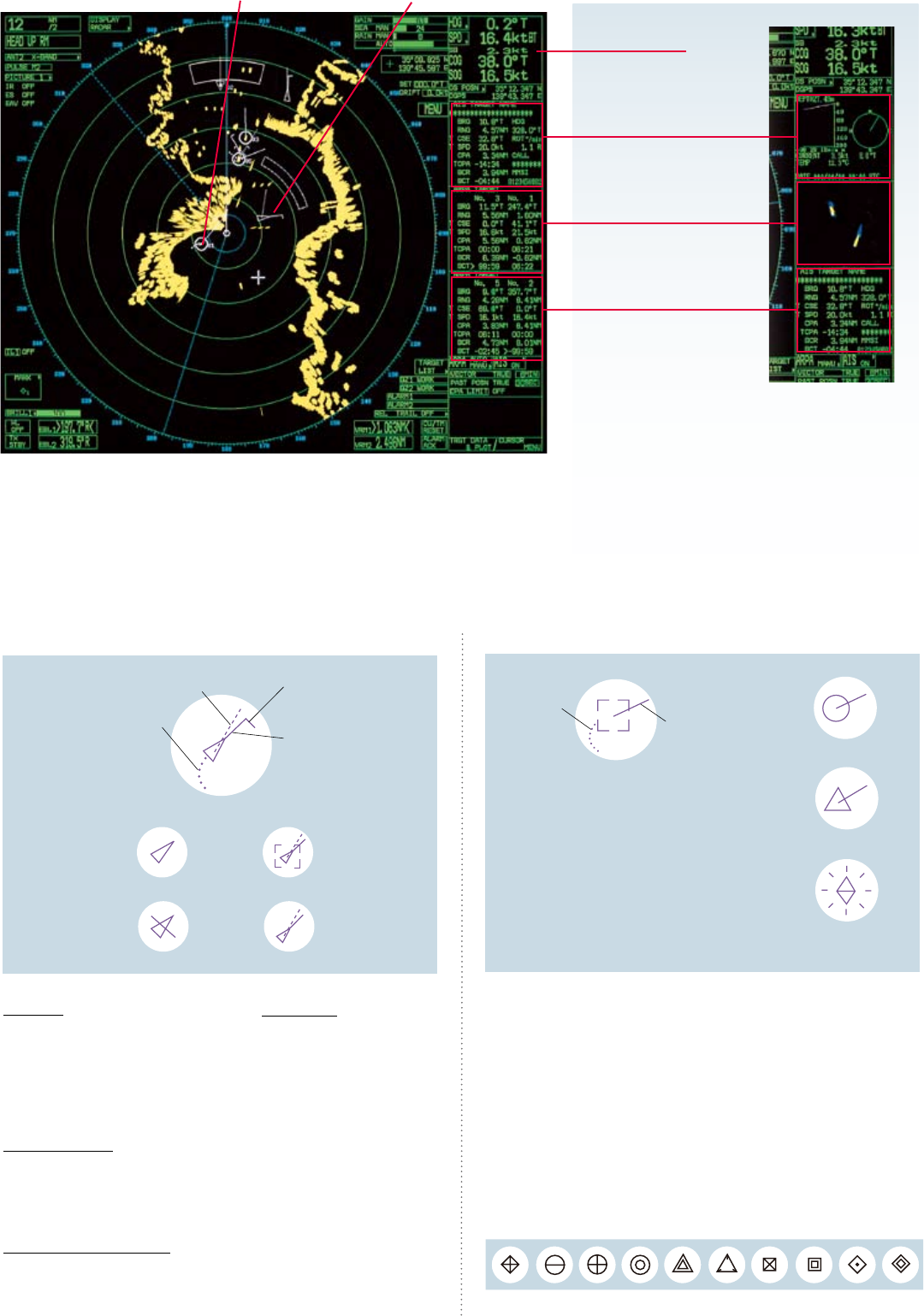
Data Display
A variety of navigational information which
is vital for shing vessels, including own
ship status, radar plotting data, wind,
water temperature and information from
other shipborne sensors can be displayed
in the data cells on the right hand side of
the screen. The FAR-2157 and 2167DS
radar have a unique zoom function which
enlarges a part of the radar image twice or
three times in size.
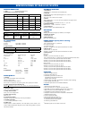
Symbols for AIS
Information to be presented
Static Data
MMSI (Maritime Mobile Service Identity)
IMO number (Where available)
Call sign & name
Length and beam
Type of ship
Location of position-xing antenna on the ship
Voyage related data
Ship’s draft
Hazardous cargo (type)
Destination and ETA
(at master's discretion)
Short safety-related messages
Free messages
Information to be exchanged
Dynamic data
Ship’s position with accuracy
indication and integrity status
Coordinated universal time (UTC)
Course over ground (COG)
Speed over ground (SOG)
Heading
Navigation status (manual input)
Rate of turn (where available)
Update rates Dependent on speed
and course alternation (2 s – 3 min)
*1 Vector shows STW
(speed thru water) and
CSE (course) when water
tracking mode is selected
at the radar. the length
of the vector changes
according to target's
speed.
Past positions
Turning direction
(ROT indicator)
Sleeping AIS Target
SOG (Speed over Ground) and
COG (Course over Ground) vector *1
Heading line *2
Selected Target
Lost Target Dangerous Target
*2 If there is no heading
data, the line points in
direction of COG.
Bearing from own ship to target in R (Relative) or T (True)
Range from own ship to target
Course Over Ground (COG)
Speed Over Ground (SOG)
Closest Point of Approach of target to own ship (CPA)
Time to CPA (TCPA)
Bow Crossing Range of target (BCR)
Bow Crossing Time of target (BCT)
Selecting the shape of ARPA symbols
After tracking a target, you can select and change the ARPA symbol shape by
placing the cursor on the symbol and hitting the “TARGET DATA” key.
It is useful to change the ARPA symbol to distinguish vessels and identify groups
of related targets.
The ARPA symbols are selectable from 10 shapes.
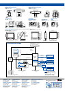
Zoom
AIS
Information
Own ship data cell
Symbols for ARPA