


GPS system characteristics/operation and NAV ONE system specifications
16
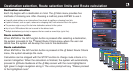
NAV ONE
. . . . . . . . . .
system
specifications
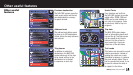
Physical Specifications
Unit dimensions
4.73" H x 7.91" W x 2.28" D
(201 mm x 120 mm x 65 mm)
Unit weight
24.4 oz.
Display size
5.2" (132 mm) Diagonal
Display resolution
320 x 240 pixel STN Color Display
Keypad
Back-lit
Power
12-volt DC vehicle
Power Adapter included
Usage 1.2A max
Fuse 3A
Antenna
Built-in Patch (Optional
External Antenna Available)
Temperature range
Operation 0˚C to + 60˚C (32˚F to 140˚F)
Storage -40˚C to + 85˚C (-40˚F to 185˚F)
Map storage
Hard Disk Drive
Performance
Receiver
12 Parallel Channels for
tracking up to 12 satellites
Acquisition times
Approximately
(hot) 8 sec.
(warm) 38 sec.
(cold) 45 sec.
using i.A.S.A.P Technology
Update rate
1/second, continuous
GPS accuracy
Position 10 meters, 2D RMS
Velocity 0.1 m/sec.
Dynamics
4g
Interface
USB 2.0
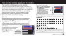
GPS basics
. . . . . . .
How GPS
. . . . . . . . .
works
The Global Positioning System (GPS) is a space-based radionavigation system. It consists of 24 satellites (which orbit the Earth at
an altitude of approximately 11,000 miles) and ground stations. GPS provides users with accurate information on position, velocity
and time. This is available anywhere in the world and in most weather conditions. GPS was initiated by The United States Department
of Defense in 1973 to reduce the proliferation of navigation aids. By creating a robust system that overcame the limitations of many
previously existing navigation systems, GPS became attractive to a broader spectrum of users. GPS has been successful in classic
applications such as aviation and marine navigation since it was first developed. Since then, it has become useful for a wide range
of people because its capabilities are accessible using small, affordable equipment.
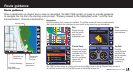
The GPS satellite network transmits radio signals to earth from high earth orbit. GPS service provides users with extremely
accurate positioning information anywhere on or near the surface of the earth. To accomplish this, each of the 24 satellites emits
signals to receivers below. GPS determines location by computing the difference between the time that a signal is sent and the time
it is received. GPS satellites carry atomic clocks that provide extremely accurate time information. The time information is placed
in the codes broadcast by the satellite so that a receiver can continuously determine the time the signal was broadcast. The signal
contains data that the NAV ONE system uses to compute the locations of the satellites and to make other adjustments needed for
accurate positioning. The NAV ONE system uses the time difference between the time of signal reception and the broadcast time
to compute the distance from the receiver to the satellite. With information about the distance to four satellites and the location
of each satellite when the signal was sent, the NAV ONE system can compute its own position: latitude and longitude.