


20
11. Locating and Tracking
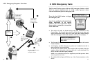
Authorized users can interrogate the Personal Tracker to receive
locations, street names and details. If present, they can poll and track
devices through Control Base software or Tracking Web services via
Internet Explorer or mobile on GPRS enabled cell phones.
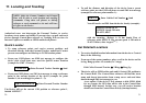
Quick Locator
¾ To setup reference points and receive current positions and
directions directly from the Personal Tracker, authorized Contact
persons can configure and label up to 5 GPS location points:
From your GSM phone, use SMS text message to configure the
device with a local time zone, used for Quick Locator function
(example for GMT +2 hours):
$TIME,02 Î Enter Personal Tracker Number Î Send
From your GSM phone, use SMS text message to setup a reference
point at the current location of the device (example for point
number 1; do accordingly for points 2 ~ 5):
$SET,1,OFFICE Î Enter Personal Tracker Number
Î Send
The Device will set the current GPS position as reference point 1,
labeled “OFFICE”.
NOTE: Only the Contact Numbers and Control
Base will be able to send location and tracking
commands. Using other cell phones or dial-up
software to send commands to the unit will have
no effect on the Device.
21
To poll the distance and direction of the device from a preset
reference point, use the GSM cell phone to send SMS text message
(example for reference point number 1):
$GET,1 Î Enter Vehicle Unit Number Î Send
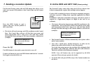
You will receive an SMS from the device shortly (example):
with the meaning: “Robert is 36 km South West of
reference point OFFICE. His current speed is 58 km/h at
19:45:23 hours, date: August 7
th
“.
Get Detailed Locations
¾ To receive detailed location information from the device or Control
Base, do the following:
From one of the contact numbers, place a call to the device and let
it ring. Hang up after 4-5 seconds (ca. 2 rings).
Dial Call to Personal Tracker Î 2 Rings ÎHang Up
The device will go GPRS online and send it’s latest GPS position to
the Control Base. The Control Base software will find the street
name and closest intersection from a map server and send these
details through SMS text message to you.
As an option, if the device’s first attempt to dial GPRS failed
for any reason, the GPS data will be sent to the Control Base
through SMS instead. In that case, you will receive location
details sent from the Control Base directly (backup feature).
Robert is 36 km SW of
OFFICE. Speed: 58 km/h,
19:45:23, 08-07