


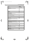

94 C-Series Display Reference Manual
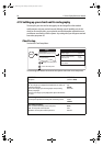
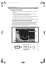
Depth Contour
A line indicating the depth at a particular position.
ALL
16ft
19ft
32ft
65ft
OFF
Nav. Marks
ON
OFF
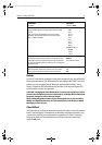
Nav. Marks Symbols
The set of symbology used for navigation marks.
Corresponds to paper charts.
International
US
Light Sectors
The sector of light cast by a fixed beacon.
ON
OFF
Caution & Routing Data
ON
OFF
Marine Features
The following cartographic features displayed on the water -
cables, nature of seabed points, tide station, current stations and
port information.
ON
OFF
Land Features
The cartographic features that are displayed on the land.
ON
OFF
Colored Seabed Areas
In available areas (e.g. Portugal) this gives greater definition of
seabed.
ON
OFF
Background Color
The color of background water when there is no Navionics cartog-
raphy.
White
Blue
Business Services
The symbols indicating the location of a business
ON
OFF
Roads
Major coastal roads
ON
OFF
Additional Wrecks
Extended wrecks data for new wrecks
ON
OFF
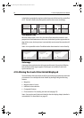
FUNCTION
Description
OPTIONS
(Default in bold)
81221_4.book Page 94 Tuesday, February 28, 2006 5:24 PM