


Chapter 3: Standard Chart Operations 3-21
Creating a New Route
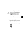
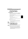
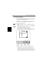
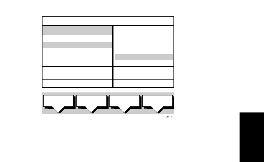
Theavailable Waypoints arelistedin theleft handcolumn (alphanumeric);the
right hand column lists the waypoints in the New Route, the number indicates
its order in the route. The lower part of the table shows position, bearing and
range of the highlighted waypoint.
You use the trackpad left/right to move control between the two columns (the
highlighted title indicates the selected column) and the trackpad up/down to
scroll through the lists.
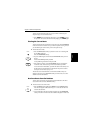
4. Select a waypoint from the Waypoint List then go to the New Route col-
umn and select a position in the list.
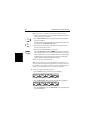
5. Press the INSERT WAYPOINT soft key to place the waypoint below the
selected position in the Route. You can have up to 50 waypoints in a route.
6. To remove a waypoint from the New Route column, highlight the way-
point and press the REMOVE WAYPOINT soft key.
Notes: (1)Awaypoint cannotbe used morethanonce ina route; thosealready
used are displayed in a lighter shade of gray.
Notes: (2)The INSERT WAYPOINT or REMOVE WAYPOINTaction adds/removes
the highlighted waypoint to/from the Route column, regardless of which col-
umn is selected.
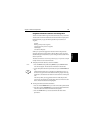
7. When all waypoints have been entered, press the ACCEPT ROUTE soft key
(or ENTER) to complete the route.
Note: The completed route is stored in the display unit and will be re-dis-
played ifyou turnthe unit off then onagain. However, onan integrated system
it is possible for a current route from another unit to overwrite this route; it is
therefore recommended that you save the route, as described in Saving the
Current Route on page 3-22.
INSERT
WAYPOINT
REMOVE
WAYPOINT
ACCEPT
ROUTE
USE
CURSOR
WAYPOINTS
MAKE ROUTE
50°50^000N
001°06^000W
COWES
GURNARD LEDGE
MAIN CHANNEL
NEEDLES FAIRWAY
PORT SOLENT
348°m 2.30nm
50°52^230N
001°02^390W
300°m 1.00nm
01 HARBOUR
02 MAIN CHANNEL
03 COWES
04 LYMINGTON
NEW ROUTE