


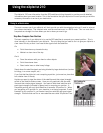


Using the eXplorist 210
11
Step Two: Where Do You Want To Go?
Now that the eXplorist knows where you are, you need to tell it where you want to go. There are many different
ways you can do this, but the simplest and most commonly used is a “GOTO” route. This is a one-leg route
with a beginning (where you are now) and a destination (where you want to go). The destination is selected by
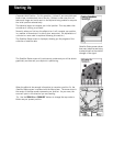
using the Points of Interest database. This database has two main options; positions you have saved (My
Points of Interest) or points of interest that have been preloaded into your eXplorist (Background Map).
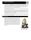
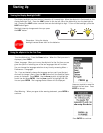
Creating a GOTO route is as simple as pressing the GOTO button and selecting the destination from the points
of interest database.
Step Three: Calculating Movement
As you move, your eXplorist is constantly calculating new positions, comparing the new position to the previ-
ous position and calculating such things as heading and speed. This is all done in the eXplorist’s software
communicating with the satellites and is instantaneously shown on your display.
Step Four: Providing Directions
Your eXplorist constantly computes a direct line from your present position to your destination. From that it
will provide you instructions to guide you along that straight path. Unless you are on a large body of water, it
will be unlikely that you will be able to follow these instructions exactly. To compensate for that, your eXplor-
ist automatically updates the route, providing you with up-to-date information about getting to your destina-
tion.
GOTO routes are the simplest and most commonly used feature of your eXplorist 210. With just the GOTO but-
ton the eXplorist will provide you with the tools needed to get to any point of interest stored in your database.
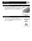
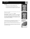
Another commonly used feature of the eXplorist is saving your position to the Points of Interest database. This
feature is accessed by pressing the MARK button. When saving your position, you can also add attributes like
a selected icon or a name for the point of interest. This will help you find this spot in the future when access-
ing it from the points of interest database.
Suppose you have set up camp for the night. Tomorrow you plan on doing some nature exploring and you want
to be able to come back to the campsite when you are done. Press the MARK button and set the name of the
point of interest to “Camp”. After your hiking is done, simply use the GOTO button and select “Camp” from
the list of My Points of Interest. It’s that simple to find your way back.
While out fishing on the lake, you come across the perfect spot for catching your limit. Next year you want to
be able to come back to this very same spot. Turn on your eXplorist and after it has computed your position,
press the MARK button to save it. This time you can enter the name “Catfish1” and save your point of interest.
Next year you can be back at the same hot spot with just a press of the GOTO button.
A simpler example, and one you can do just about any time, is finding your car in that ocean of other cars in
the shopping mall parking lot. Just park your car, step outside and let your eXplorist compute your position.
(Make sure that you have a clear view of the sky.) Using the MARK button, save this position with the name
“Car”. When you are done shopping, just go outside the mall and create a GOTO with the destination “Car”.
No matter where you parked, your eXplorist will guide you back, simply and easily.
Hikers, mountain bikers and outdoor enthusiasts often need the option of leaving a trail of breadcrumbs that
they can follow back to where they started. The eXplorist has a feature called BackTrack that enables you to
do just that.
Saving Your Position
Tracing Your Steps