


4
Plot Trails:...................... 10 savable; up to 9,999 points per trail.
Zoom range:.................... 39 ranges; 0.02 to 4,000 miles.
NOTE:
The above memory capacities refer only to the GlobalMap Baja
480c's on-board memory. The amount of GPS data you can record
and save for recall later is limited only by the number of MMC cards
you have.
NOTICE!
The storage temperature range for your GlobalMap Baja 480c is from -4
degrees to +167 degrees Fahrenheit (-20 degrees to +75 degrees Celsius).
Extended storage in temperatures higher or lower than specified will
damage the liquid crystal display in your unit. This type of damage is not
covered by the warranty. For more information, contact the factory's Cus-
tomer Service Department; phone numbers are listed on the last page.
How Lowrance GPS Works
You'll navigate faster and easier if you understand how the GlobalMap
Baja 480c scans the sky to tell you where you are on the earth — and,
where you're going. (But if you already have a working understanding
of GPS receivers and the GPS navigation system, skip on ahead to Sec-
tion 2, Installation & Accessories on page 11. If you're new to GPS, read
on, and you can later impress your friends with your new-found knowl-
edge.)
First, think of your unit as a small but powerful computer. (But don't
worry — we made it easy to use, so you don't need to be a computer ex-
pert to find your way!) The GlobalMap Baja 480c includes a keypad and
a screen with menus so you can tell it what to do. The screen also lets
the unit show your location on a moving map, as well as point the way
to your destination.
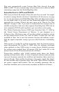
This gimbal-mounted GlobalMap Baja 480c uses an external an-
tenna/receiver module, which makes the whole system work something
like your car radio. But instead of your favorite dance tunes, this re-
ceiver tunes in to a couple of dozen GPS satellites circling the earth. (It
will also listen in to the WAAS satellites in orbit, but more about that
in the upcoming segment introducing you to GPS and WAAS.)
Your unit listens to signals from as many satellites as it can "see" above
the horizon, eliminates the weakest signals, then computes its location
in relation to those satellites. Once the GlobalMap Baja 480c figures its
latitude and longitude, it plots that position on the moving map shown
on the screen. The whole process takes place several times a second!