


28
Navigation Page, backtracking a trail while creating a new trail.
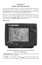
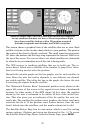
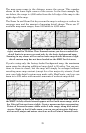
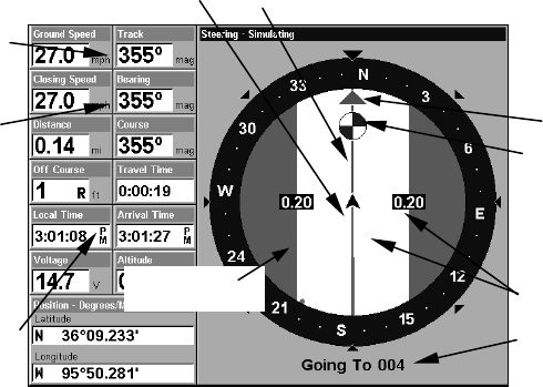
In the example figure above, the driver is headed north (a 355º track)
toward a waypoint 355º (bearing) away. The cross track error range
(white corridor) is 0.20 miles either side of the course. The driver is
headed toward trail waypoint 4, which is 0.14 miles away. The vehicle
is virtually on course (off course 1 foot to the right). Traveling at a
speed of 27 mph, the driver will arrive at the waypoint in 19 seconds.
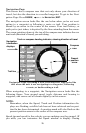
The Navigation Page has its own menu, which is used for some ad-
vanced functions and for setting various options. (Options and setup
are discussed in Sec. 5.) To access the Navigation Page Menu, from the
Navigation Page, press
MENU
.
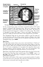
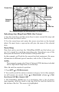
Map Page
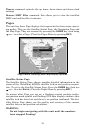
The Map Page screens show your course and track from a "bird's-eye"
view. By default, this unit shows the map with north always at the top
of the screen. (This can be changed. See the topic Map Orientation, in
Sec. 5.) If you're navigating to a waypoint, the map also shows your
starting location, present position, course line and destination. You
don't have to navigate to a waypoint, however, to use the map.
Map Page is the default screen that appears when you turn on the unit.
To get to the Map Page from another page: Press
PAGES
| → or ← to
M
AP
|
EXIT
. When the Map Page is displayed, a screen similar to the fol-
lowing figures appears.
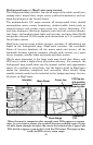
The arrow in the center of the screen is your present position. It points
in the direction you're traveling. The solid line extending from the back
of the arrow is your plot trail, or path you've taken.
Destination
name
Navigation
information
displays
Bearing
arrow
Cross track
error range
(off course
indicator)
Course line
Waypoint
s
y
mbol
Current track or
heading, shown
in degrees
Compass
bearing to
destination
Trail line
Left cross
track error line